Vision: The Upland Slopes is a climate resilient socio-ecological system, supported by a strong sense of place and pride in our engaged, knowledgeable and adaptive community.
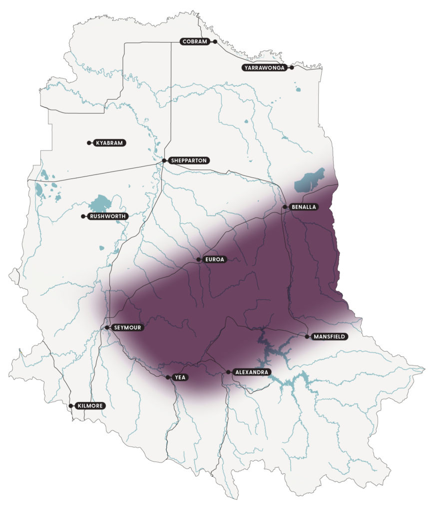
The Upland Slopes extend across the southern hills and valleys of the catchment (Figure 22). The Taungurung were the first people of the rivers, valleys and mountains in this region and the many cultural sites indicate the importance to Traditional Owners.
Forests originally covered the hills and the valleys were open grassy woodlands. More recently, the area has been dominated by agricultural land and lifestyle properties. Natural events, such as drought and bushfires have also shaped the landscape.
Although grouped as one local area, the Upland Slopes could be separated into 2 ecological areas of the upper woodlands and the lower grasslands.
Similarly, the community is not homogeneous. It would identify as 3 social groups: the Mansfield area, the Strathbogie Ranges and the area north of Lake Nillahcootie. The area includes the towns and districts of Yea, Strathbogie, Mansfield, Warrenbayne, Alexandra and Jamieson. The community accesses services in Euroa and Benalla, which are outside the local area.
Land use is a mixt of state forests, small reserves, lifestyle properties and agriculture in the cleared valleys and slopes. Agricultural practices are dominated by grazing with some intensive agriculture such as viticulture and irrigated agriculture along waterways. Land use is changing with the introduction of different crops, such as cherries, and the growth in lifestyle properties, particularly in the Strathbogie Ranges and around the larger towns.
Key features
A snapshot of the Upland Slopes natural resources is provided under the themes of biodiversity, community, land and water.
Biodiversity
Areas of native vegetation provide important habitat for wildlife and can be found in large patches along waterways and roadsides. Native vegetation is more fragmented on agricultural land and includes many large, old trees and areas of native pasture. Spring soaks are a feature, as are granite boulders and waterways, providing habitat for wildlife.
The area has 2 ecological communities: upper woodlands and lower grasslands. The common vegetation types include Herb-rich Foothill Forests, which are classified as least concern. There are also many threatened ecological vegetation classes (EVCs), such as Valley Grassy Forest which is classified as vulnerable to extinction. The remaining native vegetation and biodiversity is valued by the community for the ecosystem services it provides such as shade and shelter, economic benefits such as tourism and forestry, and social values such as recreation and lifestyle.
Significant fauna species include Environment Protection and Biodiversity Conservation (EPBC) Act listed species such as the striped legless lizard, golden sun-moth (which is endangered with extinction state and nationally) and the greater glider (which is threatened in Victoria).
Community
Many Taungurung people continue to live on Country and, with Taungurung that live elsewhere, are active in the care, protection and preservation of culture, land and waters.
Agricultural production is valued and the lifestyle opportunities of the area are increasingly appreciated by full-time and occasional residents (such as absentee landholders and weekenders).
Some of the area is commuting distance to Melbourne and has proved highly attractive for weekenders. Just under 50% of Mansfield’s ratepayers are absentee landholders.
The area provides a range of recreational and tourism opportunities. Accordingly, the service industry is a large employer.
The area is divided into 3 main social groups: around Mansfield, the Strathbogie Ranges and north of Lake Nillahcootie. The Mansfield area has the Up2Us Landcare Alliance with a dedicated facilitator and a strategic plan. The Strathbogie Ranges has several Landcare groups, networks and environmental interest groups that are engaged in NRM.
Land
The terrain is characterised by undulating hills and broad valleys with the soils generally shallow and finely structured.
Water
This area generates a considerable proportion of the catchment’s total water yield. The upper Goulburn, Howqua, Jamieson and Delatite rivers supply water to Lake Eildon, which then delivers regulated water to downstream sections of the Goulburn River. Lake Eildon is an important feature and contributes to agriculture and lifestyle in the area. The Mansfield region is the upper catchment for the Broken River which leads into Lake Nillahcootie.
Priority waterway assets are:
- Goulburn River, which is a heritage river that supports threatened species. It contains important cultural heritage sites, provides water for agriculture and urban centres in and downstream of the river basin and supports recreational activities such as fishing and boating.
- Hughes Creek, which supports threatened Macquarie perch and Murray cod.
- King Parrot Creek, which supports threatened Macquarie perch.
- Yea River, which supports threatened Macquarie perch.
- Acheron River, which is an environmental site of significance.
- Delatite River, which has a high economic value and supports threatened Murray cod.
- Sevens Creek, which is a priority waterway.
Wetlands are generally in a moderate state, but the quality is variable. There are springs that have been dug for dams, spring bogs that have hardly been altered and larger wetlands of varying health.
Priority wetland assets include:
- Yea Wetlands, which protect the nationally and internationally threatened damselfly Hemiphlebia mirabilis and extend about 10 km upstream and downstream of Yea and include the confluence of the Yea and Goulburn rivers.
- Horseshoe Lagoon, which is a billabong on the mid-Goulburn River, and one of only a few wetlands in the region in good condition.
- Mt Buller bogs, which provide water for the Delatite River and support the threatened Alpine bog community.
The Strathbogie Ranges has relatively fresh, but low-yielding, fractured rock groundwater aquifers which are mainly used for bores for domestic and stock use.
Current condition
Community engagement has identified 5 critical attributes that are fundamental to the character of the Upland Slopes:
- economy
- water
- native vegetation and amenity
- cultural heritage
- community.
The current condition and trends for each attribute are outlined in Table 36. They have been drawn from Goulburn Broken CMA annual reports, tipping points described by the community, socio-economic research and the water, land and biodiversity theme papers developed as part of the strategy renewal.
Table 36: A snapshot of current condition and trends for the critical attributes of the Upland Slopes
| Critical attribute | Description | Current condition* | Trend** |
|---|---|---|---|
| Economy | • Diverse productive agriculture. • New business opportunities. • Ability to find work. | Pressures to adapt and transform the economy means the condition varies – good to poor condition. Ability to absorb, respond, recover and renew – under pressure. | Adaptation and transformation phase. |
| Water | • Clean water. • Water in rivers and creeks. • Groundwater that is not declining. | Waterways vary in condition, with the Goulburn River considered to be in poor condition – good to poor condition. Ability to absorb, respond, recover and renew – under pressure. | Adaptation phase. |
| Native vegetation and amenity | • Natural beauty. • Diverse landscapes and biodiversity. • Unique remnant natural landscape. • Open spaces. • Tall remnant trees in forests and paddocks. | Lack of connections, climate change, pest plants and animals – poor condition. Ability to absorb, respond, recover and renew – limited. | Adaptation and transformation phase. |
| Cultural heritage | • Indigenous cultural heritage. • European heritage. | Knowledge of cultural heritage is being lost with an ageing population and small number of Taungurung people living and working on country – poor condition. Ability to absorb, respond, recover and renew – under pressure. | Adaptation and transformation phase. |
| Community | • Sense of place and belonging. • Community spirit. • Resilience to natural disasters. • Positive lifestyle opportunities. | Increasing diversity and non-resident community members, means community condition varies – good to poor. Ability to absorb, respond, recover and renew – under pressure. | Adaptation and transformation phase. |
**The trend refers to resilience phase and/or type of change the critical attribute is experiencing generally, such as persistence, adaptation or transformation.
Drivers of change
Tables 35-40 describe the 4 major drivers of change impacting the Upland Slopes and what they mean for the area’s critical attributes:
- climate change
- changing land use
- diverse and changing community attitudes
- increasing and competing priorities for public resources and changes to public policy
The drivers of change were identified through community engagement and socio-economic analysis as part of the strategy renewal.
Driver 1: Climate change
Table 37: The impacts of climate change and what it may mean for the Upland Slopes critical attributes
| Impacts | What climate change may mean for the critical attributes |
|---|---|
| • A hotter and drier climate. • Reduced reliability of rainfall in summer, spring and autumn. • Increased frequency and intensity of storms, heatwaves, bushfires and droughts. | Economy • Reduced viability for many agricultural and horticultural businesses. • Opportunities for new rural businesses compatible with climate change and carbon pricing. • Agricultural industries transitioning to meet carbon neutral targets and market demands. • Philanthropists increasingly funding projects aimed at decarbonisation. Water • Springs and dams dry up and streamflow stops more often. • Less water in rivers, lakes and dams. • Increased erosion after bushfires decreasing water quality significantly. • Changes to flow and flood regimes threaten aquatic and riparian species. • Increased low oxygen events and blue-green algae outbreaks result in poor water quality and massive fish deaths. Native vegetation and amenity • Decreasing number and health of tall trees including paddock trees, particularly in the Strathbogie Ranges. • Declining quality of large forest blocks because of changes to fire regimes. • Increasing number and intensity of bushfires threatening native flora and fauna. Cultural heritage • Extreme events threaten some cultural heritage sites. • Changes in water availability and quality impact culturally significant species and opportunities to practice culture. Community • Frequency of natural disasters exhausts the community’s financial, physical and emotional resources. • Highly stressful impact on individual health and wellbeing. • Recreation and amenity value impacted by reduced water availability and poor water quality. • Increasing support for decisions and actions that reduce climate change and its impacts. |
Driver 2: Changing land use
Table 38: The impacts of changing land use, and what it may mean for the Upland Slopes critical attributes
| Impacts | What changing land use may mean for the critical attributes |
|---|---|
| • Land management has a negative impact on native vegetation, biodiversity and wildlife. • Reduced amount of water stored in the soil profile. • Reduced amount of water flowing in local streams. | Economy • Declining dependence on the land for an income. Water • Increasing number of small dams. • Increasing demand for groundwater. Native vegetation and amenity • Logging of public land reducing diverse plant communities. • Clearing of mature trees as cropping area increases. Cultural heritage • Increasing opportunities to protect Traditional Owner values. Community • Rapid turnover of lifestyle properties. • Increasing skill gap in land managers. |
Driver 3: Diverse and changing community attitudes
Table 39: The impacts of diverse and changing community attitudes to the environment and what it may mean for the Upland Slopes critical attributes
| Impacts | What diverse and changing community attitudes to the environment may mean for the critical attributes |
|---|---|
| • Increasingly different motivations, capability and time available to act as environmental stewards as the diversity of landholders increases (such as public, farmers, lifestyle, absentee and weekenders). • Many landholders live outside the area, only visiting on holidays and weekends. • Potential decline in traditional groups, such as Landcare, and place-based participation in volunteering. • Increasing interest in participating in one-off events and online, particularly around specific issues. • Greater inclusion and interest in Traditional Owners’ ecological knowledge and First Nations culture. | Economy • Increasing range of business and employment opportunities, such as tourism and recreation. • New landholders may not have the skills to sustainably manage the natural assets. • Declining contribution of volunteers that support the paid economy. • Opportunity to promote visitation through cultural interpretation and experiences to promote the understanding of Traditional Owners’ roles and Caring for Country. Water • Increased number of small dams on the growing number of lifestyle properties. • Multiple sources of pollution from human activity reaching waterways and affecting water quality. • Increased stock and domestic demand and climate variability threatening groundwater yield, particularly as lifestyle properties expand. • Water management decisions and practices acknowledges and respects cultural values. • Increasing involvement of recreation groups putting pressure on natural assets, for example, four-wheel drive tracks that cause erosion. Native vegetation and amenity • Decline in the quality, connection and extent of grassy woodlands and forests due to changing land use and native forest logging. • Increased pressure from existing and new pest plants and animals, such as deer. • Increased respect and appreciation of the value of native vegetation for community wellbeing and livelihood. • Increased incorporation of traditional ecological knowledge and scientific knowledge in managing natural resources. • Changing population demographics resulting in decreasing attendance at community and advisory groups, such as Landcare. Cultural heritage • Increased awareness and respect for Traditional Owner culture and knowledge. • Reduced volunteer support for European heritage museums. Community • Increasingly difficult to address the range of natural resource issues where collective effort is required to improve the historical impacts and ensure current practices are sustainable, for example, native vegetation linkages. • Difficulty establishing networks between communities and agencies and reinforcing accountability. • Increases need to broaden partnerships and participation in decision making. • Opportunity to raise awareness of Traditional Owner roles and ethics of Caring for Country. |
Driver 4: Increasing and competing priorities for public resources and changes to public policy
Table 40: The impact of increasing and competing priorities for public resources and changes to public policy and what it may mean for the Upland Slopes critical attributes
| Impacts | What the increasing and competing priorities for public resources and changes to public policy may mean for the critical attributes |
|---|---|
| • Greater inclusion and interest in Traditional Owner ecological knowledge and First Nations culture, as public policy and legislative changes support greater inclusion of Traditional Owners in NRM. • Communities need to explore new investment opportunities, in addition to public resources, to meet the urgent and large-scale changes required to improve NRM. | Economy • Individuals and private businesses increasingly contribute knowledge and financial resources to deliver environmental outcomes. Native vegetation and amenity • Increasing complexity for local community and regional groups to engage in decision-making and raise local priorities. • Increasing demand for compliance activities, such as illegal native vegetation clearing and timber harvesting. • Increases in pest plants and animals reducing the resilience of existing vegetated areas and increasing the cost of protection. Cultural heritage • Recognition of Traditional Owners and First Nations heritage. Community • Increasing challenge for community groups to balance the accountability requirements for community grants (such as reporting, competitive grants and tender processes) and the available volunteer resources. • Increasing reliance on community coordinators and facilitators. |
Tipping points
Understanding and identifying tipping points of significant change is important to increasing the resilience of the Upland Slopes and its important social, economic and environmental services.
Significant change occurs when the characteristics of a system change so much that the system is no longer the same. Some tipping points are well-understood and can be used to guide management, while others are still being understood.
Planning with local communities over the past 6 years has identified tipping point for the critical attributes for the local area. They are presented in Table 41. The strategy provides an opportunity to identify and further test tipping points.
Table 41: Community tipping points for the Productive Plains critical attributes
| Critical attribute | Community tipping points |
|---|---|
| Water | • A decrease of water in rivers, lakes and dams. • A decrease in the flow of rivers and creeks. |
| Economy | • No stock, loss of topsoil and crops moving up the hills. • An increase in erosion given intense rainfall events. • An altered soil microbiology. • An increase in weed load and/or weed species not usually present in the area. |
| Native vegetation and amenity | • A decrease in the number and health of paddock trees. • Tall trees gone. • A change of flora and fauna species in relation to extreme events. |
| Cultural heritage | • Numbers of Taungurung people living and working on Country. |
| Community | • An increased difficulty in dealing with change when the population increases. • Town and rural planning issues. |
Community vision and outcomes
Community and stakeholder engagement has developed the following vision and outcomes for the Upland Slopes. The outcomes focus on what needs to happen given the impacts of the drivers of change. Priority actions have been described to deliver each of the outcomes.
Please note, the outcomes are not in priority order. All 4 outcomes are equally important and complementary. Consideration of all outcomes is required during implementation to achieve the vision.
Vision
The Upland Slopes is a climate resilient socio-ecological system, supported by a strong sense of place and pride in our engaged, knowledgeable and adaptive community.
Outcomes
- Land use and management adapts to change ensuring native vegetation, water, economy and community critical attributes remain below tipping points.
- Water use adapts to change ensuring native vegetation, economy and community critical attributes remain below tipping points.
- Local improvement in the diversity, extent and connection of native vegetation and wildlife.
- The community is cohesive, connected and collaborative.
Priority actions
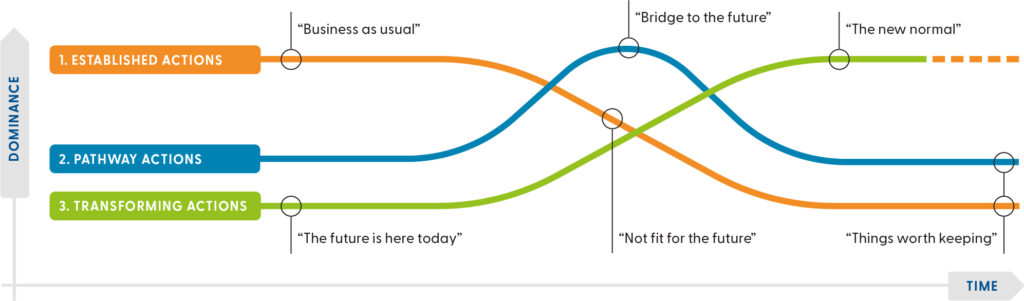
Priority actions for the Upland Slopes have been identified for each of the 4 outcomes (Tables 42-45). They provide ideas and options for the future, rather than fixed work plans. The actions must evolve as the catchment changes and new information becomes available.
The tables present priority actions for each outcome as:
- Established actions, which are those currently happening that we would like to continue. They include business as usual, recognised and existing practices. These are actions that are widespread and well-understood.
- Pathway actions, which are innovations that help shift from the current situation to an ideal future. For example, bridging or transition actions that take place during the transition from established to transforming actions.
- Transforming actions, which are the way things could work in the future. For example, the new normal, visionary ideas and new ways of doing things to create change. There may be pockets of these already happening.
A combination of all 3 types of actions is required to achieve the vision for the future (Figure 23).
Dividing actions this way is based on the Three Horizons framework and helps communities:
- think and plan for the longer-term by identifying emerging trends that might shape the future
- understand why current practices might not lead to a desired future
- recognise visionary actions that might be needed to get closer to a desired future.
Outcome 1: Land-use and management adapts to change ensuring native vegetation, water, economy and community critical attributes remain below tipping points
Table 42: Priority actions for outcome 1
| Action type | Priority actions |
|---|---|
| Established actions | • Match the Upland Slopes with areas that have the future climate given potential scenarios and identify appropriate technologies, practices, services and land use. • Strengthen the awareness and demonstration of farm practices that help adapt to climate change, such as managing soil water holding capacity. • Improve awareness of the impacts of land use and management practices on th landscape, such as weed control, installation of dams on small properties, protection of native vegetation and habitat. • Broaden the identification of areas that can expand carbon neutral energy options. • Build on the industry and market decarbonisation initiatives to support change. |
| Pathway actions | • Develop tools that quantify, measure and monitor the impact of land use and management practices on the critical attributes. • Support the development of mechanisms that credit private and public landholders and managers for ecosystem services they provide to the community. • Build the partnership, awareness and skills of the community about potential climate scenarios, technologies, services, land use options and practices from the matched climate area. • Strengthen regional planning policies and compliance to keep the critical attributes below tipping points. |
| Transforming actions | • Farming and economic land use information and services integrate environmental and community considerations. • The diverse range of public and private landholders and managers understand the impact of actions on the critical attributes, their responsibilities and how to remain below the critical attribute tipping points. • A regional carbon credit initiative is trialled that enables urban people, including visitors, to offset their climate change impacts and contribute to funds for rural land managers to use in regenerating biodiversity, native vegetation and soil health. • Re-ignite a culture of land and water stewardship among landholders and visitors. • Innovations that reduce greenhouse gas production are implemented by landholders, sch as algal supplements. |
Outcome 2: Water use adapts to change ensuring native vegetation, economy and community critical attributes remain below tipping points
Table 43: Priority actions for outcome 2
| Action type | Priority actions |
|---|---|
| Established actions | • Improve weather literacy, awareness of weather forecasting services and provide information earlier to prepare for dry seasons and climate change. • Grow and extend the development of property water budget plans that include soil water storage, evaporation losses and impacts on groundwater and local stream flows. • Increase access to information and services that support sustainable water use and management. • Match the Upland Slopes with areas that have the future rainfall under potential climate scenarios, for example using climate analogues, and identify the relevant technologies, services and land use and make them relevant and accessible. |
| Pathway actions | • Support the development of virtual centres, such as local stores, to find information, sign-post, know who to contact and find opportunities to learn. • Strengthen connections of visitors and weekenders to the area and provide opportunities to make a positive difference to water, private and public land and biodiversity. • Improve lifestyle landholder education on surface water storage, groundwater use and the impacts beyond properties. • Quantify the impact of land and water use under climate change on water availability and stream flow. • Build the partnership, awareness and skills of the community about potential climate scenarios, water technologies, services and land use from the matched climate area. |
| Transforming actions | • Planning and land use change requirements include consideration of the available water and water use limits. |
Outcome 3: Local improvement in the diversity, extent and connection of native vegetation and wildlife
Table 44: Priority actions for outcome 3
| Action type | Priority actions |
|---|---|
| Established actions | • Programs to increase the permanent protection and improvement of habitat on private farming and lifestyle properties. • Strengthen the management of pest grazing animals, such as deer, and weeds to protect biodiversity and reduce the cost and failure of revegetation efforts. • Modify the offset revegetation mechanism to ensure replacement vegetation is the same ecological vegetation class and replaced in the same area. • Strengthen the opportunities for individuals and groups in public land management and decision-making. • Build on the landholder carbon audit initiative to increase participation and ensure the protection of remnant vegetation. • Renew the regional biodiversity implementation plan to coordinate action and investment across a range of partners to increase native vegetation extent. • Implementation of the Victorian Forestry Plan to phase out all native timber harvesting by 2030, while supporting workers, businesses and communities. • Creation of Immediate Protection Areas (such as the Strathbogie Ranges), additional protections for old growth forests and improved management of Victoria’s forest to protect remnant vegetation (such as review of the code of forest practice for timber harvesting, major event review of regional forest agreements). |
| Pathway actions | • Develop a biodiversity plan that prioritises remaining biodiversity, provenance shifts due to climate change and the strategic links required to support resilience. • Support the development of a payment system for the use of native vegetation and wildlife for recreation and business purposes, such as hiking and tourism, that funds management and rehabilitation. • Quantify and build awareness of the increased economic, lifestyle and health benefits from native vegetation and biodiversity. • Support the community to understand and embrace the provenance shift that is occurring due to climate change and make decisions about biodiversity in a landscape context and across a range of climate scenarios. • Expand the use of the carbon audit methodology for public land to identify the costs of native vegetation decisions. |
| Transforming actions | • Build the biodiversity plan into the local planning scheme to guide the strategic protection, linking and regeneration activities. • Implement protection and management mechanisms for biodiversity that are identified as high priority in the biodiversity plan. • Private landholders form alliances to ensure the extent and diversity of native vegetation is not reduced, and are supported by appropriate incentives and compliance mechanisms. • Landholders are funded for the value they create from biodiversity improvements and management, such as carbon, recreation and health. • Effective implementation of a mix of regulation, compliance, incentives and education targeted at the diverse users of the area. |
Outcome 4: The community is cohesive, connected and collaborative
Table 45: Priority actions for outcome 4
| Action type | Priority actions |
|---|---|
| Established actions | • Work with shire councils and Landcare networks to develop and distribute information packs for new landholders so they understand obligations, groups to link into and how to get involved. • Improve awareness of new landholders and farmers about community groups, resources and services to support the management of water, biodiversity and land. • Create links between government and landholders to enable issues to be heard where and when decisions are made, and enable funding and the needs of the community to be met. • Build capacity of agency partners and Traditional Owners to engage in partnerships with shared priorities and outcomes. • Build community respect and support for Traditional Owners’ knowledge, culture and values. |
| Pathway actions | • Develop new approaches to involve volunteers, for example, one-off, non-resident and issue-focused opportunities. • Develop new approaches to strengthen relationships and alliances between the groups, sectors, industries and initiatives that use, manage, resource or care for the natural resources • Greater inclusion and interest in Traditional Owners’ ecological knowledge and First Nations culture. • Work with CFA to discuss and/or implement fuel management activities with a focus on cultural practices, biodiversity and protection of lives and property. |
| Transforming actions | • A stewardship approach unites the groups, sectors, industries, alliances and initiatives that use, manage, resource or care for the natural resources. • Community planning approaches respond to potential future scenarios. • Traditional Owner-led land management decision making and implementation. |
References and further information
Barr N (2018) Socio-economic indicators of change – Goulburn Broken and North East CMA Regions [PDF 21.31MB], Natural Decisions Pty Ltd.
Benalla Rural City (2020) Council Plan 2017-2021 (2020 Review) [PDF 26MB], Benalla Rural City, Benalla.
Goulburn Broken CMA (Catchment Management Authority) (n.d.) Upland Slopes Local Plan [PDF 673.87KB], Goulburn Broken CMA, Shepparton.
Mansfield Shire Council (2016) Council Plan 2017-2021, Mansfield Shire Council, Mansfield.
Mitchell Shire Council (2016) Council_Plan_2017-2021 [PDF 1.73MB], Mitchell Shire Council, Broadford.
Murrindindi Shire Council (2016) Council Plans 2017-2021, Murrindindi Shire Council, Alexandra.
Strathbogie Shire Council (2016) Council Plan 2017-2021, Strathbogie Shire Council, Euroa.
Up2Us Landcare Alliance (n.d.) Strategic objectives and pillars, Up2Us Landcare Alliance website.
Show your support
Pledge your support for the Goulburn Broken Regional Catchment Strategy and its implementation.