Vision: The Commuting Hills has a safe, sustainable future and a great quality of life, while protecting and enhancing the wonderful natural environment.
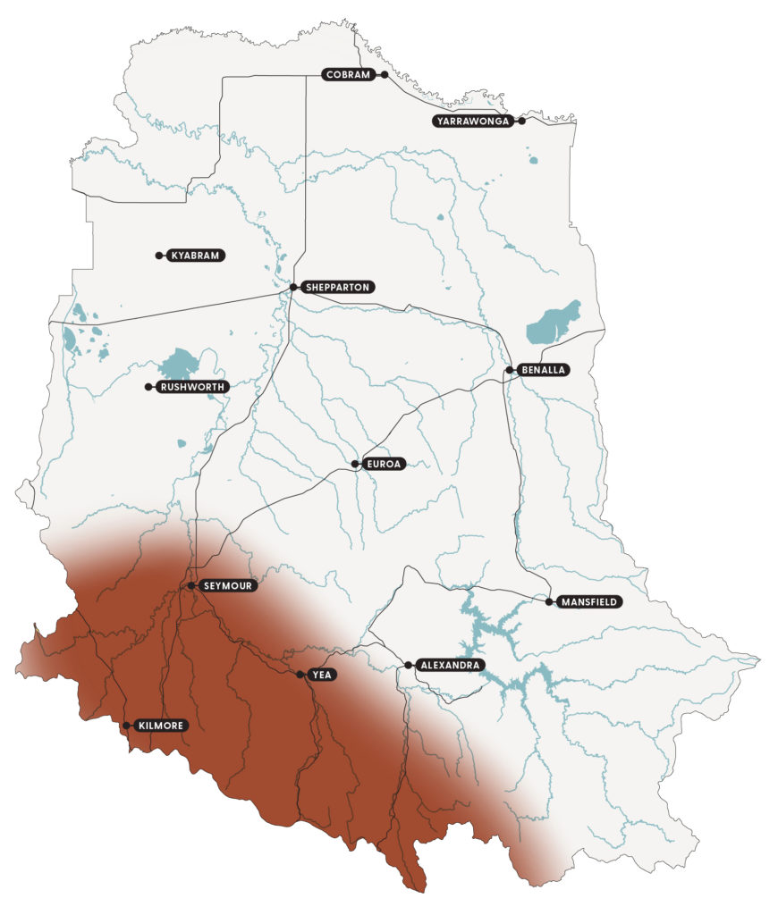
The Commuting Hills feature the mountainous urban fringe of the southern and south-western area of the catchment (Figure 24).
Traditional Owners originally shaped the land and the many cultural sites indicate the importance of the area. European settlement later led to the clearing of land for agriculture, gold rushes, urban development and rail and road infrastructure.
Large tracts of public land and small privately owned forested land remain over much of the area. Public land use includes extensive native forests, recreation and production forestry. Private land use is typically for lifestyle properties, intensive agriculture (such as berry farming and aquaculture) and grazing on cleared valleys and slopes.
Key features
A snapshot of the Commuting Hills natural resources is provided under the themes of biodiversity, community, land and water.
Biodiversity
Significant biodiversity assets have been retained and protected in large areas of publicly and privately owned forests. Some of the public forest has now been classified as state park, containing endangered or vulnerable vegetation types such as dry forest and shrubby dry forest.
Additionally, several important reserves enclose other significant flora and fauna species, such as the Mount Piper Education Area which contains 5 species of wallaby grass.
The area is important for populations of the nationally threatened large and small ant-blue butterfly, golden sun moth, bibon’s toadlet and the crimson spider orchid, which is endangered in Victoria and vulnerable in Australia. Other threatened species in the area include western rat-tail grass, yellow star, slender bitter cress, creeping grevillea, matted flax lily, Macquarie perch, barking owl, powerful owl, diamond firetail and speckled warbler.
Community
Many Taungurung people continue to live on Country and, with Taungurung that live elsewhere, are active in the care, protection and preservation of culture, land and waters.
The population is growing, with families drawn to the area for its lifestyle, visual appeal and affordability. People are moving to the area and commuting to Melbourne for work. This means the area is more densely populated, more urban, structurally younger and wealthier than other areas of the catchment.
The area is also home to the Puckapunyal Military Area, a major base located on an area of over 37,000 ha west of Seymour.
The Murrindindi and Mitchell Shire councils play an important role in coordinating natural resource interest and management. Both shires have a range of natural resource advisory groups made up of community members and supported by a shire officer.
Land
The terrain is characterised by undulating hills and broad valleys, with the soils generally shallow and finely structured with high organic matter.
Water
Surface water assets are critical in providing constant yields of filtered high-quality water for human consumption.
Priority waterway assets are:
- King Parrot Creek, which supports threatened Macquarie perch.
- Yea River, which supports threatened Macquarie perch.
- Acheron River, which is an environmental site of significance.
- Taggerty River, which contains ecologically healthy and representative reaches and supports threatened barred galaxias.
In addition, the local community has identified Kilmore, Mollisons, Dabyminga/Reedy, Sunday and Dry Creeks as priorities.
Aquifer systems deplete quickly in response to reduced rainfall recharge.
Groundwater use is increasing and primarily used for stock and domestic supply, and in some cases for community and urban water supply, for example, in Kinglake.
Current condition
Community engagement has identified 5 critical attributes that are fundamental to the character of the Commuting Hills:
- economy
- water
- native vegetation and wildlife
- rural landscape
- community.
The current condition and trends for each attribute are outlined in Table 46. They have been drawn from Goulburn Broken CMA annual reports, the tipping points described by the community, socio-economic research and the water, land and biodiversity theme papers developed as part of the strategy renewal.
Feedback received through the strategy renewal process has added to these critical attributes.
Table 46: A snapshot of current condition and trends for the critical attributes of the Commuting Hills
| Critical attribute | Description | Current condition* | Trend** |
|---|---|---|---|
| Economy | • Employment opportunities. • Business opportunities. | Access to Melbourne creates opportunities – good condition. Ability to absorb, respond, recover and renew – stable. | Adaptation and transformation phase. |
| Water | • Reliable. • Good quality and quantity. | Rural water demand regularly greater than supply – poor condition. Surface water systems – moderate to good condition. Ability to absorb, respond, recover and renew – limited. | Adaptation phase. |
| Native vegetation and wildlife | • Diverse land of sustainable extent and quality. • Remnants and revegetation. | Pressure from urban and rural development and bushfires – poor condition. Ability to absorb, respond, recover and renew – limited. | Adaptation and transformation phase. |
| Rural landscape | • Mix of agriculture that is sustainable. • Old trees across the landscape. | Pressure from urban and rural development and bushfires – good to poor condition. Ability to absorb, respond, recover and renew – under pressure. | Adaptation and transformation phase. |
| Community | • Services and access across area and to Melbourne. • History, culture and place. | Physical and digital connections stable or increasing, connections between people are challenged – fair condition. Ability to absorb, respond, recover and renew – under pressure. | Adaptation phase. |
**The trend refers to resilience phase and/or type of change the critical attribute is experiencing generally, such as persistence, adaptation or transformation.
Drivers of change
Tables 47-49 outline the 3 major drivers of change impacting the Commuting Hills and what they mean for the area’s critical attributes:
- climate change
- urban and rural development
- diverse and changing community attitudes.
The drivers of change were identified through community engagement and socio-economic analysis as part of the strategy renewal.
Driver 1: Climate change
Table 47: The impacts of climate change and what they may mean for the Commuting Hills critical attributes
| Impact | What climate change may mean for the critical attributes |
|---|---|
| • A hotter and drier climate. • Reduced reliability of rainfall in spring and autumn. • Increased frequency and intensity of storms, heatwaves, bushfires and droughts. | Economy • Increasing frequency of blue-green algae outbreaks impacting tourism. • Increase in bushfires impacting forestry and tourism. • Weather extremes impacting public transport to Melbourne. • Fewer frosts for fruit set in horticultural enterprises. Water • Increased stream temperatures impacting salmonid fish species. • Unreliable and reduced water supplies on semi-rural properties and in streams. • Decreasing water quality, for example, increases in blackwater events and erosion following bushfires. • Increased threat of droughts and floods to water availability from aquifers, affecting the recharge processes, baseflows to waterways and water quality. Native vegetation and wildlife • Increasing rate of decline of remaining native vegetation. • Increased impact of bushfires on threatened species and communities. • Increasing boom and bust of native pest species, such as lerps, kangaroos and mosquitoes. Rural landscape • Increasing threat to the amenity and recreation values of native vegetation, rivers, streams and lakes. • Reduction in trees from bushfires, or in response to concern about bushfire risk. Community • Increasing frequency of natural disasters exhausts the community’s financial, physical and emotional resources. |
Driver 2: Urban and rural development
Table 48: The impacts of urban and rural development and what they may mean for the Commuting Hills critical attributes
| Impacts | What urban and rural development may mean for the critical attributes |
|---|---|
| • Increasing population growth. • Decreasing openness of agricultural land. • Increasing urban areas and number of hobby farms. • Increasing the number of families. • Increasing construction employment. • Increasing dormitory style living, where people travel to Melbourne during the day. | Economy • Increasing amount of the population earning a living that is not connected to agriculture. • Increasing distance between where people live and work. • Increasing service and recreation-oriented employment, such as health and hospitality. Water • Groundwater availability under pressure. • Increasing risk of water-use exceeding supply in most years. • Increasing number of small dams affecting stream flows. • Increasing impact on recharging of groundwater and its subsequent impact on streams and wetlands. • Increasing risk of illegal extraction affecting flows. Native vegetation and wildlife • Clearing of vegetation and reduced connection between remaining vegetation. • Increased weed and non-native species and pests, such as serrated tussock, gorse, blackberry, Paterson’s curse, phalaris, deer, foxes, dogs and cats. Rural Landscape • Increasing threat to the rural feel of the landscape. Community • Reducing number of people available to volunteer. • Reducing skills for managing natural resources. |
Driver 3: Diverse and changing community attitudes
Table 49: The impact of diverse and changing community attitudes and what they may mean for the critical attributes
| Impact | What diverse and changing community attitudes may mean for the critical attributes |
|---|---|
| • Increase in urban views of natural resources as parkland rather than natural environment. • Increase in concerns about trees, native vegetation and bushfires. • Increase in small dams on subdivided land. • Increase in demand for services, such as health and education. | Economy • Increased pressure on farmers dealing with urban values and pest animals, and vice versa. • Fewer people dependent on the land for an income. Water • Increasing range of expectations about water availability and supply. • Water quality is under threat. • Increasing invasive species in waterways, including European carp. Native vegetation and wildlife • Pressure to clear native vegetation for fire control. • Reducing membership and contribution to Landcare and other environment-based activities. • Increasing area of native vegetation on private land protected by covenants. • Increasing gap in the use of public land and the money spent managing it. Rural landscape • Increasing diversity of opinion about which rural landscapes need to be retained. Community • Increasing disconnect between urban and rural values. • Less community cohesiveness and contribution to the community. |
Tipping points
Understanding and identifying tipping points of significant change is important to increasing the resilience of the Commuting Hills and its important social, economic and environmental services.
Significant change occurs when the characteristics of a system change so much that the system is no longer the same. Some tipping points are well-understood and can be used to guide management, while others are still being understood.
Planning with local communities over the last 6 years has identified tipping points for the critical attributes for the local area. They are presented in Table 50. The Strategy provides an opportunity to identify and further test tipping points.
Table 50: Community tipping points for the Commuting Hills critical attributes
| Critical attribute | Community tipping point |
|---|---|
| Water | • Water does not meet demand and water quality is not fit-for-purpose. • Demand for water exceeds supply in the rural landscape. • A decrease in the flow of rivers and creeks. |
| Economy | • Stream temperatures increase more than 20 degrees Celsius. • Fire frequency in mountain ash is more than every 5-20 years. • Blue-green algae frequency in Lake Eildon is every 3 years. |
| Native vegetation | • Local extinctions. • Reduced extent and diversity. |
| Community | • School closures. • Increased level of mental health issues. |
Community vision and outcomes
Community and stakeholder engagement helped develop the following vision and outcomes for the Commuting Hills. The outcomes focus on what needs to happen given the impacts of the drivers of change. Specific priority actions have been described to deliver each of the outcomes.
Please note, the outcomes are not in priority order. All 3 outcomes are equally important and complementary. Consideration of all outcomes is required during implementation to achieve the vision.
Vision
The Commuting Hills has a safe, sustainable future and a great quality of life, while protecting and enhancing the wonderful natural environment.
Outcomes
- Land and water use are adapting to change ensuring native vegetation, water, economy and community critical attributes remain below tipping points.
- Local improvement in the diversity, extent and connection of native vegetation and wildlife.
- The community is cohesive, connected and collaborative.
Priority actions
Priority actions for the Commuting Hills have been identified for each of the 3 outcomes (Tables 51-53). They provide ideas and options for the future, rather than fixed work plans. The actions must evolve as the catchment changes and new information becomes available.
The tables present priority actions for each outcome as:
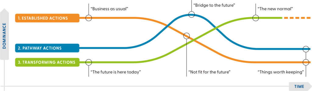
- Established actions, which are those currently happening that we would like to continue. They include business as usual, recognised and existing practices. These are actions that are widespread and well-understood.
- Pathway actions, which are innovations that help shift from the current situation to an ideal future. For example, experiments, bridging or transition actions that take place during the transition from established to transforming actions.
- Transforming actions, which are the way things could work in the future. For example, the new normal, visionary ideas and new ways of doing things to create change. There may be pockets of these already happening.
A combination of all 3 types of actions is required to achieve the vision for the future (Figure 25).
Dividing actions this way is based on the Three Horizons framework and helps communities:
- think and plan for the longer-term by identifying emerging trends that might shape the future
- understand why current practices might not lead to a desired future
- recognise visionary actions that might be needed to get closer to a desired future.
Outcome 1: Land and water use are adapting to change ensuring native vegetation, water, economy and community critical attributes remain below tipping points
Table 51: Priority actions for outcome 1
| Action types | Priority actions |
|---|---|
| Established actions | • Grow and extend the development of property water budget plans and integrated water management principles that include soil moisture storage, water recycling, evaporation losses and impacts on groundwater and local stream flows in rural and urban areas. • Information packs for prospective, new and absent landholders so they know their obligations, practical land management, groups to link with and how to get involved. • Increase the use of, and links to, local expertise for the development of land and water management plans to build a stewardship culture and increase compliance with landholder obligations. • Continue to implement stream-frontage and wetland works with adjacent landholders to maximise the delivery of waterway values. • Increase new landholder’s involvement and understanding of land capability and NRM through the Land Management Plan process required when getting a planning and/or building permit. |
| Pathaway actions | • Build in future climate change and population scenario impacts and risks in local government planning, permit requirements and land and water use planning. • Support the development of virtual centres to find information, who to go to and opportunities to learn. • Improve awareness about land management that has an impact at a broader landscape scale, such as weed control, installation of dams on small blocks, groundwater, care of animals and land in dry conditions and ramifications of not protecting native vegetation and habitat. • Implement practices to improve land health and address the impact of historical land management practices. • Develop and implement a water efficiency program for a range of landholders. |
| Transforming actions | • Planning and land use requirements to include available water and water use limits. • Weirs and fish passages are reviewed in response to climate change. |
Outcome 2: Local improvement in the diversity, extent and connection of native vegetation and wildlife
Table 52: Priority actions for outcome 2
| Action types | Priority actions |
|---|---|
| Established actions | • Investigate opportunities to increase the protection of habitat for native species on private lifestyle, urban and absentee properties. • Modify the offset revegetation mechanism to ensures that replacement vegetation is the same EVC and replaced in the same region. • Increase the monitoring and understanding of the importance of mature trees by expanding the Bogies and Beyond paddock tree project and use of the Tree Health app. • Increase the revegetation of the critical linkage features and vegetation corridors in priority landscapes to improve context, in particular from east to west. • Increase the management of small parcels of public land by understanding why it is failing and options for the future, for example, schools. |
| Pathway actions | • Increase the value of biodiversity on farms and lifestyle blocks by promoting the link to increased amenity and land prices. • Monitor and communicate changes in the extent of native vegetation to the managers and regulators of public and private land. • Broaden revegetation options, provenance and practices so they support the flexibility needed to adapt to changes in climate policies and the types of landholders. • Support pest animal and weed control and management programs. • Identify key east-west biolinks (such as Mount Piper Biolink) that deliver biodiversity priorities and compliment the often north-south orientation of waterways. • Create links between owners of covenanted properties to share skills, approaches and materials. • Strengthen regional planning policy and compliance to protect priority native vegetation with appropriate planning decisions and public land management. |
| Transforming actions | • Revegetation decisions are resilient under future climate scenarios. • Net-extent measures are integrated in planning and management decisions for private and public land. • Increased compliance is supported by the implementation of a mix of incentives, engagement and education targeted at the diverse range of landholders and users. • Public and private land managers are set targets, actions and monitoring practices to maintain and improve native vegetation diversity and quality. |
Outcome 3: The community is cohesive, connected and collaborative
Table 53: Priority actions for outcome 3
| Action types | Priority actions |
|---|---|
| Established actions | • Improve awareness, expansion and connection to community groups, links and services, particularly for new landholders and farmers. • Target prospective buyers and new owners of small properties with educational resources, mentors on land capability, options to meet practical management requirements and environmental opportunities and impacts. For example, delivery could be through real estate agents, on-line resources, or Section 32s. • Create a one-stop-shop for prospective, new and existing landholders to assist in resolving land and water management issues and to understand their obligations and opportunities for improvement. |
| Pathway actions | • Public land managers and government organisations regularly consult and collaborate with Traditional Owners on NRM planning and implementation. • Build capacity of agency partners and Traditional Owners to engage in partnerships with shared priorities and outcomes. • Build community respect and support for Taungurung as the guardians of Taungurung Country. • Support the community to understand and embrace the provenance shift that is occurring due to climate change. • Improve the understanding of the motivations, knowledge and behaviours of established, lifestyle landholders, visitors and recreational users of the area. • Expand the use of apps to link new members, visitors and community members with services or advice needed to manage land, biodiversity and water. • Create volunteering opportunities for the urban population, lifestyle owners and visitors to the region. • Support NRM groups and networks to maintain momentum and offer engagement events that embrace diversity. • Complete flood mapping to ensure all creeks have appropriate controls to minimise the impacts of flooding. • Expand partnerships to include services and groups that people interact with as they consider, or move to, the area, such as real estate agents. • Reignite land stewardship, incorporating Traditional Owner values where permitted. • Support the development of mechanisms that credit private and public landholders and managers for the use of native vegetation and the ecosystem services they provide. • Work with CFA to discuss and implement fuel management activities with a focus on cultural practices, biodiversity and protection of lives and property. |
| Transforming actions | • Environmental stewardship is embraced by the community, including visitors, and leads to collaboration between diverse groups and sectors that use, manage, fund or care for the natural resources. • Landholders are funded for the value they create from biodiversity improvements and management, such as carbon, recreation and health. • Investment from a range of sectors, such as health, transport and tourism, delivers NRM projects with dual benefits. • Private land managers and businesses regularly consult and collaborate with Traditional Owners on NRM planning and implementation. • Traditional Owners lead NRM decision-making and implementation on public land. |
References and further information
Barr N (2018) Socio-economic indicators of change – Goulburn Broken and North East CMA Regions [PDF 21.31MB], Natural Decisions Pty Ltd.
Goulburn Broken CMA (Catchment Management Authority) (n.d.) Commuting Hills Local Plan [PDF 626.72KB], Goulburn Broken CMA, Shepparton.
Mitchell Shire Council (2016) Council_Plan_2017-2021 [PDF 1.73MB], Mitchell Shire Council, Broadford.
Murrindindi Shire Council (2016) Council Plans 2017-2021, Murrindindi Shire Council, Alexandra.
Show your support
Pledge your support for the Goulburn Broken Regional Catchment Strategy and its implementation.