Vision: The Agricultural Floodplains community leads Australia in producing food in harmony with the environment.
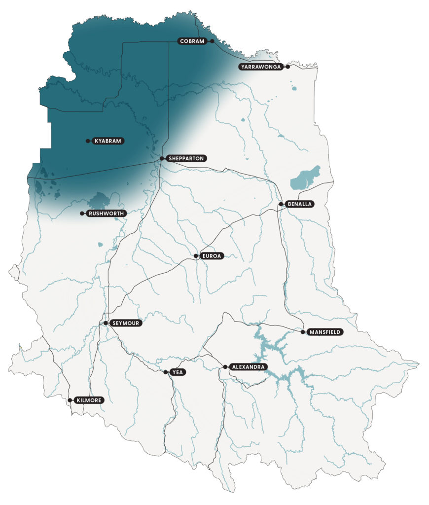
The Agricultural Floodplains encompass the Shepparton Irrigation Region and the north-eastern parts of the catchment to the Murray River (Figure 18). It includes the towns of Shepparton, Cobram, Nathalia, Yarrawonga, Tatura, Kyabram, Tongala and Numurkah.
The region has a rich Aboriginal heritage and a First Nations population of more than 6,000, the largest in regional Victoria.
Yorta Yorta Nation Aboriginal Corporation, which includes 8 clans, has statutory responsibilities for managing traditional cultural heritage and Crown land in Yorta Yorta Country. The balance of the area to the west is under the umbrella of the Taungurung Land and Waters Council.
The arrival of Europeans in the mid-1800s, soldier settlement schemes and more recent international migrants have added to a culturally diverse community.
The changing land use has included clearing for dryland and irrigation farming, construction of irrigation and drainage networks and urban settlement. These have seriously impacted the area’s biodiversity, with most of the remaining habitat and vegetation along waterways and roadsides.
Key features
A snapshot of the Agricultural Floodplains natural resources is provided under the themes of biodiversity, community, land and water.
Biodiversity
The area is well-placed in terms of agricultural production. This places a heavy demand on soil, water and biodiversity resources. The biggest threats to biodiversity are clearing, degradation and non-regeneration of native vegetation, such as paddock trees. The biodiversity condition is poor.
In the early to mid-1900s, farmers were paid to remove trees and establish soldier settlement style blocks. Vegetation loss has occurred incrementally since then through clearing, the impact of watertables and senescence. Many species of plants and animals have become extinct or are just hanging on. Most landscapes across the area are past the tipping points for long-term survival.
The area was originally:
- open grassy woodlands dominated by river red gum forests and black box trees across the floodplain
- plains grassy woodlands dominated by grey box, white box, yellow box and a myriad of wattles and understorey species
- shallow sand woodlands dominated by Murray pine, buloke, yellow box and associated shrubs found on sand ridgelines
- open plains woodland and northern plains grassland are dominated by groundcovers such as herbs and grasses.
There are many key native vegetation areas including:
- waterways
- natural depressions, such as Mosquito, Muckatah and Timmering
- well vegetated roadsides, public land reserves and national parks, such as the Goulburn River, Broken Boosey, Lower Goulburn, Barmah and the Murray River
- wetlands, such as Reedy Swamp, Doctors Swamp, Bray’s Swamp and Kinnairds Wetland
- private land, with paddock trees and remnants.
There are a range of threatened fauna and vegetation communities in the landscape, such as the superb parrot, grey-crowned babblers and the Northern Plains grassland.
Barmah Forest is located on the Murray River floodplain between Tocumwal and Echuca and is Victoria’s largest River Red Gum reserve (approximately 28,500 ha). Together with the adjoining Millewa Forest in NSW, the Barmah-Millewa Forest is one of 6 icon sites of The Living Murray Program managed by the Murray-Darling Basin Authority. The forest has been reserved as a National Park, and is also Ramsar listed, containing internationally significant wetlands that support many threatened native plants, birds, fish, frogs and reptiles.
Community
The largest regional centre is Greater Shepparton. It has a diverse, harmonious and vibrant multicultural population with over 4% First Nations people and 16% born overseas.
The local government areas include the City of Greater Shepparton, Campaspe Shire Council and Moira Shire Council. Regional centres include Cobram and Yarrawonga and smaller regional towns are Nathalia, Tatura, Kyabram, Tongala and Numurkah.
Although most of the population lives and works in urban centres, agricultural production dominates land-use and includes dairy, horticulture and cropping. Agricultural production is supported by processing and manufacturing industries that are highly valued for their economic benefit.
Land
The area is an extensive and complex alluvial plain. Sodic soils dominate the plains, while some sandhills exist near the Murray and Goulburn rivers. The soils of the alluvial plain have a strong texture contrast between the surface (A horizons) and the dense sodic subsoils (B horizons).
Following European settlement, most of the land was cleared for agriculture except for riparian areas, roadsides and scattered remnants. Irrigated agriculture became the dominant land-use in the first half of the 20th century. Post-war soldier settlements and the post-1950 agricultural technology boom greatly influenced land and water use.
Water
The river ecosystems are a dominant feature with rivers, streams and creeks generally flowing north to meet the Murray River. Victoria’s largest river, the Goulburn River, winds through the local area and Australia’s largest river, the Murray River, runs along the northern border.
Many of the major waterways are regulated to support urban needs, environmental flows and irrigated agriculture. These systems typically receive environmental flows to help improve their ecological health.
The Shepparton Irrigation Region covers approximately 500,000 ha, including 300,000 ha of irrigated agriculture. This region includes the Murray Valley, Shepparton, Central Goulburn and Rochester irrigation districts. Annual irrigation water delivery (surface water) ranges between approximately 400-900 ML but is variable depending on water allocation (seasonal conditions) and has been trending down over the last 10 years. This is supplemented by rainfall, with average rainfall across the region ranging from 420-480 mm per year.
Due to a modernised irrigation delivery system, productive soils and favourable seasonal conditions, the region is internationally renowned for its highly productive, efficient and sustainable agriculture. It produces approximately $1.4 billion in agricultural production across irrigated dairy, horticulture, cropping and mixed-farming. Cropping and dairy remain the 2 largest land and water users in the area.
Groundwater is a significant resource consisting of the Shepparton Irrigation Region Groundwater Management Area (GMA) to a depth of 25 m, and the deeper (deep lead) Katunga, Broken, Mid-Goulburn and West Goulburn GMAs. They are used for irrigation, domestic supply and stock purposes.
Local area plans and groundwater management plans are developed by Goulburn Murray Water to provide information about the groundwater system and how the resource is used and managed.
Priority waterway assets include:
- Goulburn River, which is a heritage river associated with wetlands of national significance and supporting threatened species including Murray cod, silver perch and Macquarie perch. It features many cultural heritage sites and provides water for agriculture, urban and recreational use.
- Seven Creeks, which supports the threatened trout cod and Macquarie perch.
- Gobarup Creek, which is associated with wetlands of national significance.
- Broken River, which is associated with wetlands of national significance and supports the threatened Murray cod, Macquarie perch and silver perch.
- Broken Creek, which supports the threatened Murray cod and is associated with wetlands of international significance.
Thirty-four of the catchment’s significant wetlands form a critical part of the river ecosystems of the Agricultural Floodplains area.
The current condition of wetlands in the Agricultural Floodplains is moderate to good. Wetlands on public land are generally in better condition than private land, mainly due to size. Private land wetlands are generally considered to be in poor condition. The biggest threats to wetlands are river regulation, drainage and landforming.
Priority wetlands assets include:
- Barmah Forest, which is Ramsar listed and contains internationally significant wetlands that support many threatened native plants, birds, fish, frogs and reptiles. It is one of Victoria’s largest waterbird breeding areas and protects 38 rare or threatened plant species.
- Kanyapella Basin, which is a mixed river red gum forest and black box woodland which protects the nationally threatened river swamp wallaby grass and provides flood retardation.
- Muckatah Depression, which is a long and narrow prior stream depression connecting larger wetlands. It protects multiple threatened plant species and provides important habitat for waterbirds including the threatened brolga.
- Corop Wetland Complex, including Gaynor swamp, supports thousands of water birds and is a priority cultural landscape for Taungurung people.
- Wanalta Wetland Complex, which is 4 hydrologically connected wetlands valued for their size, rarity, species diversity and waterbird habitat.
- Kinnairds Wetland, which is a red gum wetland that protects Victoria’s largest known population of the nationally threatened rigid water milfoil. It also provides important breeding habitat for waterbirds including the threatened royal spoonbill.
- Black Swamp, which is a small red gum swamp that protects the nationally threatened river swamp wallaby grass and Australasian bittern.
- Carlands Swamp, which is a private wetland that includes the most eastern Victorian area of the Tangled Lignum Swamp.
Current condition
During development of the Shepparton Irrigation Region Land and Water Management Plan (2016-2020), community engagement identified 5 critical attributes that are fundamental to the character of the Agricultural Floodplains and what residents value most about where they live:
- farm and regional viability
- water tables
- water availability
- water quality
- native vegetation extent.
The current condition and trends for each attribute are outlined in Table 14. They have been drawn from the Shepparton Irrigation Region Land and Water Management Plan, critical attribute reviews that are conducted annually with the community, Goulburn Broken CMA annual reports, socio-economic research, and the water, land and biodiversity theme papers developed as part of the strategy renewal.
Feedback received through the strategy renewal process has added to these critical attributes.
Table 14: A snapshot of current condition and trends for the critical attributes of the Agricultural Floodplains
| Critical attribute | Description | Current condition* | Trend** |
|---|---|---|---|
| Farm and regional viability | • Predominantly dairy, horticulture and cropping. • Agriculture related food processing, other industries and manufacturing exist. • Climate change, land health and associated issues are impacting farm and regional viability. | Comparative advantage of the region – poor condition. Ability to absorb, respond, recover and renew – under significant pressure. | Adaptation and transformation phase. |
| Water tables | • Shallow ground water aquifers are managed. • Deep lead aquifers are managed. • Public and private groundwater management infrastructure exists. • Without intervention, salinity and waterlogging will be risks on irrigated areas following rainfall. | Mature groundwater management infrastructure – good condition. Ability to absorb, respond, recover and renew – good condition. | Persistence phase. |
| Water availability | • Volume, reliability, and security of regulated supply are key issues. • Overland flows are not occurring naturally. • Rainfall is critical for the area. • There is a highly competitive water market. • Reliable and affordable modernised irrigated water supply and systems exist. • Environmental water, floodplain health, waterway management and cultural heritage are key issues. | For the environment – good to fair condition. Irrigated agriculture – poor condition. Ability to absorb, respond, recover and renew – poor condition. | Adaptation and transformation phase. |
| Water quality | • Nutrients, salinity, blue green algae and hypoxia events are key issues. • Clean water for consumption is a necessity. • Drains, groundwater, rivers, streams, dams, lakes and wetlands are critical assets. | Mature water quality programs – good to fair condition. Ability to absorb, respond, recover and renew – fair condition. | Persistence phase. |
| Native vegetation extent | • Native vegetation exists on farms, such as paddock trees, along roadsides, streams and riparian areas. • Includes terrestrial, wetlands and waterways vegetation, such as scattered remnants and paddock trees. • Management is needed for native vegetation, targeting extent, and associated ecosystems against threatening processes such as direct removal and climate change. | Native vegetation – poor condition. Ability to absorb, respond or recover and renew – limited. | Transformation phase. |
**The trend refers to resilience phase and/or type of change the critical attribute is experiencing generally, such as persistence, adaptation or transformation.
Drivers of change
Tables 15-18 outline 4 major drivers of change impacting the Agricultural Floodplains and what they mean for the area’s critical attributes:
- climate change
- changing land use
- increasing number and extent of pest plants and animals
- diverse and changing community attitudes.
The drivers of change were identified through community engagement and socio-economic analysis as part of the strategy renewal.
Driver 1: Climate change
Table 15: The impacts of climate change and what they may mean for the Agricultural Floodplains critical attributes
| Impacts | What climate change may mean for the critical attributes |
|---|---|
| • A hotter and drier climate. • Reduced reliability of rainfall in spring and autumn. • Increased frequency and intensity of storms, heatwaves, bushfires and droughts. | Farm and regional viability • Additional resources are needed to adapt farming systems, such as feed reserves, opportunistic cropping, precision and efficient farming. • Grazing and cropping land management needs to respond to water availability and resources such as soil and ground cover. • Increased heat stress for livestock and crops. • Fewer frosts resulting in reduced fruit set in horticultural enterprises. • Increased risk of late season frosts and crop failure. Water tables • Fluctuating water table levels with decreased winter rainfall may reduce recharge and salinisation, while increased intensity of summer rainfall may recharge water tables and raise salinity levels. Water availability • Declining volumes and reliability of water for irrigation. • Increasing risk of running out of water for stock, fire control, domestic and dryland use. Water quality • Increased risk of blue-green algae outbreaks and hypoxic events. • Increased uncontrolled storm run-off resulting in spikes in nutrients and erosion. Native vegetation extent • Increased rate of decline and health of remaining native vegetation. • Increased opportunities and investment in climate mitigation projects, such as revegetation and permanent protection of native plantings. |
Driver 2: Changing land use
Table 16: The impacts of changing land use and what they may mean for the Agricultural Floodplains critical attributes
| Impacts | What changing land use may mean for the critical attributes |
|---|---|
| • Increased demand for lifestyle blocks close to towns and water. • Larger farms. • Changed irrigation footprint. • Changed value for farm irrigation investment, for example, irrigation infrastructure no longer reflected in land value. • Development of renewable energy zones. | Farm and regional viability • Increased rural land prices due to lifestyle property demand make it difficult for agricultural businesses to expand. • Increased difficulty controlling pest animals and weeds with more lifestyle properties. • Increased planning related matters due to land use conflicts, such as noise, odour and amenity values, which impact the notion of a right-to-farm. • Increased number and area of solar farms. Water tables • Opportunities for flexible management of private groundwater bores, such as saving funds while decommissioning in wet years and recommissioning as required. Water availability • Increased competition for water delivered through the river systems from in and outside the catchment impacting availability. • Need for planning and policy direction to better match water volume and reliability. Water quality • Increased impact from lifestyle properties with direct access to water on water quantity and quality downstream. Native vegetation extent • Increased removal of scattered trees, fragmentation and a loss of sensitive and valuable habitat due to clearing. • Opportunity to identify alternative income sources. • Increased or decreased protection of larger remnants on private land depending on larger corporate business models. |
Driver 3: Increasing number and extent of pest plants and animals
Table 17: The impacts of an increasing number and extent of pest plants and animals and what they may mean for the Agricultural Floodplains critical attributes
| Impacts | What an increasing number and extent of pests may mean for the critical attributes |
|---|---|
| • Increased demand for weed management (with a declining budget for agencies) especially for species such as arrowhead, azolla, boxthorn, caltrop, blackberry and ornamental trees. • Difficulty managing pest species on public and private land. • Increased populations of predatory animals, such as foxes and cats. • Ongoing populations of pest birds, such as Indian minors. • Ongoing populations of European carp. | Farm and regional viability • Increasing and competing priorities for public resources creating a need for public land managers to find new investment opportunities, (in addition to public resources) to meet pest, plant and animal control needs. Water • Need for ongoing management of fast growing native water plants, such as azolla, in waterways. Native vegetation extent • Declining quality of native vegetation due to increases in grazing pest animals and weeds. |
Driver 4: Diverse and changing community attitudes
Table 18: The impacts of diverse and changing community attitudes and what they may mean for the Agricultural Floodplains critical attributes
| Impacts | What diverse and changing attitudes may mean for the critical attributes |
|---|---|
| • Increasing interest in agriculture from lobby groups and possible negative views of farming. • Less stable, less connected and more stressed communities. • More fragmented community and landholder groups with less volunteering. • An ageing farming population, with an average time on the land of 35 years. • Corporate farming responding to priorities set outside the local community. | Farm and regional viability • Increased difficulty controlling pest animals and weeds with more lifestyle properties. • Increased potential for land use planning conflicts with more lifestyle properties. • Increased costs and risks for livestock management to minimise odour, noise and dust when next to residential land. • Change to the way businesses operate with invoice payments. • Increased purchases of new machinery and infrastructure. • Loss of existing farm infrastructure. Water tables • Increased requests for access to groundwater and land with groundwater infrastructure. Water availability • Increased demand for water from a range of users, such as lifestyle and urban dwellers and the associated cost to Goulburn-Murray Water. • Increased pressure on the public supply system as supply and demand profiles change. Native vegetation • Increased difficulty addressing natural resource issues where collective effort is required, such as native vegetation linkages. • Changed nature of extension with less people living on-farm and more off-farm managers. • Challenged assumption that enough of the community will do the right thing, such as stewardship, with an increasing number of people only valuing personal benefits. • Decline in traditional groups, such as Landcare, CFA and hall committees, and place-based participation in natural resource volunteering. • Opportunities to access new volunteers and investment through different engagement models as the broader community (including visitors) increasingly values nature. • Increased collection of firewood impacting ground habitat. |
Tipping points
Understanding and identifying tipping points of significant change is important to increasing the resilience of the Agricultural Floodplains and its important social, economic and environmental services.
Significant change occurs when the characteristics of a system change so much that the system is no longer the same. Some tipping points are well-understood and can be used to guide management, while others are still being understood.
Planning with local communities over the last 6 years has identified tipping points for the critical attributes for the local area. They are presented in Table 19. The strategy provides an opportunity to identify and further test tipping points.
Table 19: Community tipping points for the Agricultural Floodplains critical attributes
| Critical attribute | Community tipping point |
|---|---|
| Farm and regional viability | • These tipping points are under development with input from the Farm and Environment Working Group and Shepparton Irrigation Region People and Planning Integration Committee. |
| Water tables | • Shallow water tables in the Shepparton Irrigation Region are maintained below 2 m for at least 50% of the irrigated landscape. |
| Water availability | • 880 GL of water for agriculture in the Shepparton Irrigation Region in an average 100% allocation season. This tipping point is currently under review. • 1 in 100 year average recurrence interval of flooding becomes more frequent. • Urban water delivery restrictions remains below level 3 80% of the time in 80% of delivery systems. |
| Water quality | • 80% of water quality parameters are managed in State Environment Protection Policy tolerance limits 100% of the time. • Broken River median salinity at Casey’s Weir end-of-valley target site of less than 141 electrical conductivity (EC) units, a formal target of 141% of median baseline conditions. • Goulburn River median salinity at Goulburn Weir end-of-valley target site of less than 99 electrical conductivity (EC) units. |
| Native vegetation | • Less than 30% of native vegetation extent, which is when an ecosystem’s function starts to decline. • Less than 10% native vegetation cover, which results in exponential loss of bird species. • More than 50 m between habitats, which impacts landscape connectivity for vertebrates. • A minimum depth of 25 m or a total of 50 m across a stream or wetland. |
Community vision and outcomes
Community and stakeholder engagement has developed the following vision and outcomes for the Agricultural Floodplains. The outcomes focus on what needs to happen given the impact of the drivers of change. Specific priority actions have been described to deliver each of the outcomes.
Please note, the outcomes are not in priority order. All 6 outcomes are equally important and complementary. Consideration of all outcomes is required during implementation to achieve the vision.
The Agricultural Floodplains local area plan will be considered in future land and water management planning, including the Shepparton Irrigation Region Land and Water Management Plan.
Vision
The Agricultural Floodplains community leads Australia in producing food in harmony with the environment.
Outcomes
- Agriculture is adapting to change, ensuring farm and regional viability, water and native vegetation critical attributes remain below tipping points.
- Shallow water tables are managed so at-risk soil zones are not salinised or waterlogged.
- Water is available to match the needs of the environment, agriculture and social consumption.
- Water quality is maintained or improved for a range of beneficial uses.
- The extent and health of native vegetation is increased.
- The community is cohesive, connected and collaborative.
Priority actions
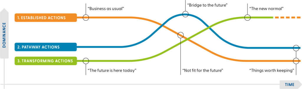
Priority actions for the Agricultural Floodplains have been identified for each of the 6 outcomes (Tables 20-25). They provide ideas and options for the future, rather than fixed work plans. The actions must evolve as the catchment changes and new information becomes available.
The tables present priority actions for the outcomes as:
- Established actions, which are those currently happening that we would like to continue. They include business as usual, recognised and existing practices. These are actions that are widespread and well-understood.
- Pathway actions, which are innovations that help shift from the current situation to an ideal future. For example, experiments, bridging or transition actions that take place during the transition from established to transforming actions.
- Transforming actions, which are the way things could work in the future. For example, the new normal, visionary ideas and new ways of doing things to create change. There may be pockets of these already happening.
A combination of all 3 types of actions is required to achieve the vision for the future (Figure 19).
Dividing actions this way is based on the Three Horizons framework and helps communities:
- think and plan for the longer-term by identifying emerging trends that might shape the future
- understand why current practices might not lead to a desired future
- recognise visionary actions that might be needed to get closer to a desired future.
Outcome 1: Agriculture is adapting to change, ensuring farm and regional viability, water and native vegetation critical attributes remain below tipping points
Table 20: Priority actions for outcome 1
| Action type | Priority actions |
|---|---|
| Established actions | • An adaptive Shepparton Irrigation Region Land and Water Management Plan with demonstrated processes that consider change, impact and responses. • Completion of the 30 year Shepparton Irrigation Region Land and Water Management Plan and review of achievements. • Application of the Northern Victorian Irrigation Development Guidelines to ensure that new irrigation developments meet high standards. • Land and water use mapping and data analysis. • 10% of farmers are assisted each year to make changes that improve farm viability and provide long-term public benefits. • Whole farm planning and extension activities supporting whole property planning. • Energy and irrigation system performance assessments. • Awareness of the benefits of technology to support decision making in agriculture, such as the soil moisture monitoring pilot project). • Research to understand the impact of climate change on agricultural land and water use. Examples include reviewing and updating the Climate Smart Agricultural Development program and integration of renewable energy options in the Agricultural Floodplains, including Central North Renewable Energy Zone. • Awareness and adoption of circular economy principles and new technologies, such as changing agricultural waste into energy sources. |
| Pathway actions | • Community awareness and ownership of the Goulburn Murray Resilience Strategy, which aims to improve the resilience of the area. • Farmers and designers have access to information that allows them to factor environmental sensitivities into planning. • Developers and landholders have access to a central point of contact for land use change and irrigation development in the Goulburn Murray Irrigation District, such as the Agriculture Redevelopment Coordination Pilot Project. • 60% of irrigated farms are redesigned to capitalise on, and align with, modernised irrigation delivery. • Technology and information support systems are adopted by farmers to improve decision making, such as soil moisture monitoring devices to support irrigation scheduling. • Traditional Owner values and knowledge of land use is incorporated. |
| Transforming actions | • Implementation of the Goulburn Murray Resilience Strategy improves the resilience of the area, including the agricultural sector. • Development of a data information platform that creates a one-stop-shop for landholders or developers to transform properties with soil, water and system information. • 90% of the irrigation delivery system is modernised, with all irrigated land connected. • Grow the local food experience for visitors and local communities to connect with where their food comes from, and for farmers to value-add to their produce. |
Outcome 2: Shallow water tables are managed so at-risk soil zones are not salinised or waterlogged
Table 21: Priority actions for outcome 2
| Action type | Priority actions |
|---|---|
| Established actions | • Irrigated land is protected from salinity and waterlogging threats by a coordinated private and public drainage network. • Strategic planning reduces the risk of soil salinity and waterlogging. |
| Pathway actions | • Groundwater pumps are ready for use to mitigate risk from high watertables. • The new hybrid drainage program is implemented in some areas. |
| Transforming actions | • Development of the Goulburn Murray Irrigation District Drainage Management Strategy. • There is widespread implementation of the hybrid drainage program, linking natural assets such as wetlands. |
Outcome 3: Water is available to match the needs of the environment, agriculture and social consumption
Table 22: Priority actions for outcome 3
| Action type | Priority action |
|---|---|
| Established actions | • Develop a prospectus that describes opportunities for the diverse value water provides, including for local jobs, businesses, environment and cultural heritage. • Five seasonal watering proposals developed annually for priority waterways and wetlands to meet environmental outcomes, with consideration of agricultural and social needs. • Ensuring the right environmental balance through the inter-valley transfer system to ensure positive outcomes of investments in the health of the lower Goulburn River. • Encourage broader community support for the Goulburn Murray Irrigation District Water Leadership Group advocacy for water security. • Regular completion of land and water use mapping, including Aboriginal Waterway Assessments to identify cultural values, threats to those values and management actions required to heal Country. • Understanding and updating water and land use changes to consider their meaning for the Goulburn Murray Irrigation District. • Recognising and encouraging wetland management and wildlife breeding opportunities on irrigation properties to increase the ecosystems services they provide. • Continue supporting the development of shared understanding of water security and future directions across the region. |
| Pathway actions | • Clear decision making process regarding the value of water, considering the diverse value and benefits water provides, including for local jobs, businesses, environment and cultural heritage. • Community awareness and ownership of the Goulburn Murray Resilience Strategy which aims to improve the resilience of the area, including waterway health. |
| Transforming actions | • Implementation of the Goulburn Murray Resilience Strategy improves the resilience of the area and waterway health. • The irrigation network is recognised as a holistic environmental system providing a range of habitat types and ecosystem services. |
Outcome 4: Water quality is maintained or improved for a range of beneficial uses
Table 23: Priority actions for outcome 4
| Action type | Priority actions |
|---|---|
| Established actions | • Water quality is improved or maintained to meet set targets in waterways by managing the impacts of irrigated agriculture and other activities appropriately. • Environmental flows are implemented based on scientific recommendations to maintain or improve water quality, particularly in high risk locations. • The existing water quality monitoring system is maintained. • Investment is sought for research projects into water quality issues such as blue-green algae and low dissolved oxygen. |
| Pathway actions | • Maintain partnerships and address opportunities to improve water quality under new legislative guidelines. • Research how to best manage water quality issues such as blue-green algae and low dissolved oxygen challenges. |
| Transforming actions | • Remote automated water quality monitoring and information systems are used to inform management actions. |
Outcome 5: The extent and health of native vegetation is increased
Table 24: Priority actions for outcome 5
| Action type | Priority actions |
|---|---|
| Established actions | • Revegetation and remnant protection projects increase the extent of native vegetation and create landscape corridors to help the movement of native species. • Delivery of environmental water to priority floodplain systems to enhance the health of remnant vegetation, such as river red gum forests. • Delivery of programs that increase landholder and community awareness of the value of native vegetation and biodiversity to land management. |
| Pathway actions | • Strengthen the regional planning policy and compliance to protect the remaining native vegetation with appropriate planning decisions and public land management practices. • Reduce illegal firewood collection by supporting the transition to alternative heating and providing more opportunities for legal firewood collection, such as timber felled by storms. • Increase community connection with nature through more efficient installation of green infrastructure, including shared paths, interpretative signage and so on, by more timely, flexible and adaptable approval processes. • Increasing numbers of landholders value native vegetation, and actions to retain and regenerate native vegetation on private land is supported through a range of incentives, such as native vegetation offsetting and carbon farming. |
| Transforming actions | • Large areas of native vegetation are reconnected through new corridor plantings, including along rivers, roadsides, public and private land. • Implement protection, management and compliance mechanisms to ensure the remaining biodiversity is protected. • Increased retention and regeneration of native vegetation on-farm as it provides income through native vegetation offsetting and carbon farming. •Increased area of remnant floodplain vegetation receiving adequate inundation to support long-term health and function. |
Outcome 6: The community is cohesive, connected and collaborative
Table 25: Priority actions for outcome 6
| Action type | Priority actions |
|---|---|
| Established actions | • Strategic planning and decision-making includes community and industry groups, agencies and individuals and supports a shared vision. • Building the principles of land stewardship and Traditional Owner values into farming systems. • Build on citizen science opportunities to support research and knowledge of the natural environment, climate change and other drivers of change. • Support new and existing community groups to pursue diverse volunteering activities. • Participation by individuals, groups, organisations and agencies in partner projects contributing to the goals of the Goulburn Murray Resilience Strategy and the Shepparton Irrigation Region Land and Water Management Plan. • Shepparton Irrigation Region People and Planning Integration Committee is accountable by demonstrated processes and actions that contribute to Shepparton Irrigation Region Land and Water Management Plan implementation. • Renewal of the Shepparton Irrigation Region Land and Water Management Plan 2021-2030. • Build capacity of agency partners and Traditional Owners to engage in partnerships with shared priorities and outcomes. • Engagement of Traditional Owners in the renewal of local and regional strategic plans, such as the Shepparton Irrigation Region Land and Water Management Plan 2021-2030. |
| Pathway actions | • Community-led ideas, actions and research increase stewardship of the areas natural resources. • Traditional Owner knowledge and perspectives are included in local and regional strategic plans. • There is increased involvement of Traditional Owners in agricultural projects. • Work with CFA to discuss and implement fuel management activities with a focus on cultural practices, biodiversity and protection of lives and property. |
| Transforming actions | • Widespread environmental stewardship*, incorporating Traditional Owner values, is embraced by the community and visitors. • Traditional Owners lead NRM decision making and implementation on public land. |
References and further information
Barr N (2018) Socio-economic indicators of change – Goulburn Broken and North East CMA Regions [PDF 21.31MB], Natural Decisions Pty Ltd.
Campaspe Shire Council (2016) Council Plan 2021-2026 [PDF 12.92MB], Campaspe Shire Council, Kyabram.
Goulburn Broken CMA (Catchment Management Authority) (n.d) Shepparton Irrigation Region Land and Water Management Plan 2016-2020, Goulburn Broken CMA, Shepparton.
Greater Shepparton City Council (2016) Council Plan 2017-2021, Greater Shepparton City Council.
Moira Shire Council (2016) Council Plan 2017-2021, Moira Shire Council, Cobram.
Show your support
Pledge your support for the Goulburn Broken Regional Catchment Strategy and its implementation.