Vision: Through strong, supportive community networks, the Productive Plains balances land productivity, quality water access and native vegetation quantity and condition in a changing climate.
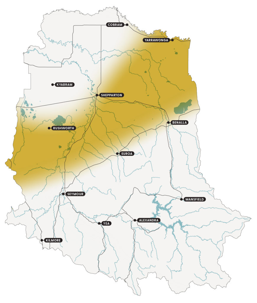
The Productive Plains run across the lower slopes and plains of the central catchment and include the towns of Nagambie, Euroa, Violet Town, Dookie and Tungamah (Figure 20). The area’s abundant food and water resources were first used by the Yorta Yorta and Taungurung Clans and the many cultural sites indicate its importance to Traditional Owners.
Since European settlement, land use has included clearing for farming, gold rushes, the post-1930s farm mechanisation boom and the 1950s wool boom. This changing land use has had a major impact on the area’s biodiversity. Most of the remaining habitat is provided by vegetation along waterways, roadsides, ranges and spring soak wetlands.
While rivers and creeks remain unregulated (except the Goulburn and Broken rivers), they are only in moderate condition. Community networks, such as the Gecko CLaN, Longwood Plains Conservation Management Network and many others, have established and provided support to landholders over the past 20-30 years to adopt sustainable farming practices and protect threatened species.
Growing consumer demand for greener agricultural products and the increasing sense of urgency among the community for climate change action, has the potential to create new opportunities for NRM across the Productive Plains.
Key features
A snapshot of the Productive Plains natural resources is provided under the themes of biodiversity, community, land and water.
Biodiversity
The current area of terrestrial habitat is small and fragmented, particularly on the more fertile plains, with a native vegetation cover of 10-30%. Most of the remaining native vegetation is along the rivers, streams and roads, with larger forest blocks occurring on the less fertile stony hills. This remaining vegetation is limited in species diversity and fallen timber due to firewood collection.
The high value biodiversity assets include the Warby Ranges, Reef Hills State Park, Dookie Hills and Chesney Hills, as identified through NaturePrint and local knowledge.
The key threatened communities include box grassy woodlands and creek-line grassy woodlands in the Goldfields bioregion.
The key threatened species include the threatened woodland bird community, bush stone-curlew, grey-crowned babbler, swift parrot and regent honeyeater and flora such as the Euroa guinea flower, orchids and species associated with grasslands.
Community
Many Traditional Owners continue to live on Country and, with those that live elsewhere, are active in the protection and preservation of their culture, land and waters.
The Productive Plains can be split into four broad social areas: Yarrawonga, Benalla/Euroa, Nagambie and Tooborac. Benalla/Euroa has the greatest number of people and connections across the Productive Plains.
Agriculture is a relatively important employer in the region and, apart from the areas in close proximity to towns or the Hume Freeway such as Benalla and Nagambie, the value of land is little influenced by amenity pressures so the farms are relatively large. The equine industry is also significant throughout the region, with numerous breeding and racing facilities.
The agricultural service providers and community organisations, such as Riverine Plains Inc. and Longwood Plains Conservation Management Network, create links between the different areas through an industry or issue focus. Other organisations, such as local farming or Landcare groups, tend to create links in a more localised area.
The community values the area for its agricultural productive capacity, water resources, diversity of landscapes, remaining native vegetation and the rural community lifestyle.
Land
The terrain is characterised by undulating hills and broad valleys with soils generally comprising of granitic and mudstone which are highly erosive, due to terrain and/or soil type, and highly acidic.
Water
Surface water comes from the Strathbogie Ranges and surrounding hills and meanders across the plains. Waterways are largely unregulated, except for the Goulburn and Broken rivers, and are generally in moderate condition.
Priority waterway assets include:
- Goulburn River, which is a heritage river associated with wetlands of national significance that support threatened species including Murray cod, silver perch and Macquarie perch. It has cultural heritage sites and provides water for agriculture, urban centres and recreational use.
- Gobarup Creek, which is associated with wetlands of national significance.
- Hughes Creek, which supports threatened Macquarie perch and Murray cod.
- Broken River, which is associated with wetlands of national significance and supports threatened Murray cod, Macquarie perch and silver perch.
- Broken Creek, which is associated with wetlands of national significance.
- Holland Creek, which supports threatened Macquarie perch.
- Ryans Creek, which contains an ecologically healthy reach.
The wetlands are generally in a moderate to good condition.
Priority wetland assets include:
- Doctors Swamp, which is one of the most intact river red gum swamps in Victoria. It supports a diverse number of species including 73 wetland flora species and 44 wetland fauna species including the nationally threatened Sloane’s froglet. It can receive environmental water from irrigation infrastructure.
- Winton Wetlands, which is the largest wetland restoration project in the Southern Hemisphere. They provide important habitat for many waterbirds including the migratory Latham’s snipe and protect 7 nationally threatened flora species.
- Tahbilk Lagoon, which is a large billabong connected to the Goulburn River. It is a biological hot spot that protects several threatened species including the broad-shelled turtle, the most southerly remnant freshwater catfish population and the largest known watershield, a native waterlily, population in Victoria.
- Moodie Swamp, which is a large cane grass wetland that provides important habitat for waterbirds including the threatened brolga. It protects the nationally threatened rigid water milfoil.
- Reedy Lake at Nagambie, which is as a place of cultural significance to Taungurung people.
The area’s ground water asset is the Mid-Goulburn Deep Lead aquifer system, associated with the Goulburn River. The larger aquifers support agriculture and provide stock and domestic water supplies.
Current condition
Community engagement has identified 4 critical attributes that are fundamental to the character of the Productive Plains:
- agriculture
- water
- native vegetation and wildlife
- community.
The current condition and trends for each attribute are outlined in Table 26. They have been drawn from Goulburn Broken CMA annual reports, tipping points described by the community, socio-economic research and the water, land and biodiversity theme papers developed as part of the strategy renewal.
Feedback received through the strategy renewal process has added to these critical attributes.
Table 26: A snapshot of current condition and trends for the critical attributes of the Productive Plains
| Critical attribute | Description | Current condition* | Trend** |
|---|---|---|---|
| Agriculture | • Healthy soils. • Planning for climate change. • Range of agricultural commodities such as beef, wool, sheep meat and crops. | Pressures to adapt and transform the economy means the condition varies – good to poor condition. Ability to absorb, respond, recover and renew – under pressure. | Adaptation and transformation phase. |
| Water | • Dams. • Access to winter-fill licences. • Water in the rivers and creeks. • Groundwater not declining. | Demand for rural water is regularly greater than supply – poor condition. Surface water systems – moderate condition. | Adaptation phase. |
| Native vegetation and wildlife | • Remnants and revegetation. • Environmental features such as lakes, rivers and wildlife, particularly birds. • On farms including paddock trees, along roadsides and streams. | Conservation reserves are too few and small to sustain wildlife in the plains (Bennett 1998) – poor condition. Ability to absorb, respond, recover and renew – limited. | Adaptation and transformation phase. |
| Community | • Resilience to natural disasters. • Sense of belonging, welcoming of new people and ideas. • Diversity of employment and lifestyle opportunities available. | The increasing diversity and reduced central community hubs means community condition varies – good to poor. Ability to absorb, respond, recover and renew – under pressure. | Adaptation and transformation phase. |
**The trend refers to resilience phase and/or type of change the critical attribute is experiencing generally, such as persistence, adaptation or transformation.
Drivers of change
Tables 25-30 outline the 4 major drivers of change impacting the Productive Plains and what they mean for the area’s critical attributes:
- climate change
- changing land use as the area transitions to a services economy
- increasing number and extent of pest plants and animals
- diverse and changing community attitudes.
The drivers of change were identified through community engagement and socio-economic analysis, as part of the strategy renewal.
Driver 1: Climate change
Table 27: The impacts of climate change and what they may mean for the Productive Plains critical attributes
| Impacts | What climate change may mean for the critical attributes |
|---|---|
| • A hotter and drier climate. • Reduced reliability of rainfall in spring and autumn. • Increased frequency and intensity of storms, heatwaves, bushfires and droughts. | Agriculture • Poor coverage of soils leading to erosion and poor soil health. • Additional resources needed to adapt farming systems, such as changing stock joining time, condensing lambing periods, reducing stock regularly, requirement for more feed reserves, opportunistic cropping and precision farming. • Running out of water for stock, fire control and domestic use. • Lower soil water holding capacity due to reducing soil carbon. • Declining productivity for grazing and cropping country. • Increased heat stress for livestock and crops. • Fewer frosts resulting in reduced fruit set in horticultural enterprises. • Increased opportunities for summer growing pastures and crops. • Increased risk of late season frosts and crop failure. Water • Climate variability, reduced recharge and over extraction threaten the larger groundwater aquifer assets. • Unreliable winter-fill licence, fluctuating availability of bore and surface water to fill dams. • Farm dams have a greater risk of algal blooms in higher temperatures and with lower water levels. • Fluctuating water table levels, with decreased winter rain reducing recharge and salinisation, while increased intensity of summer rainfall may lead to recharge water tables and raise salinity levels. • Increasing importance of holding water in the soil and groundwater. Native vegetation and wildlife • Increasing rate of decline of the remaining native vegetation. • New native species to the area. • Threatened amenity and recreation value of native vegetation, rivers, streams and lakes. Community • Frequency of natural disasters exhausts the community’s financial, physical and emotional resources to prepare, recover and grow. |
Driver 2: Changing land use as the area transitions to a services economy
Table 28: The impacts of changing land use as the area transitions to a services economy and what they may mean for the Productive Plains critical attributes
| Impacts | What changing land use may mean for the critical attributes |
|---|---|
| • Urban population growth. • Increasing demand for lifestyle properties close to towns. • Increasing rural land prices with demand for lifestyle properties in high amenity areas, such as Nagambie, and areas close to towns, such as Benalla. • Employment in health and retail is significant and increasing across the area, while agriculture remains an important employer. • Declining terms of trade for agricultural commodities as input prices and labour costs increase at greater rates than commodity prices. | Agriculture • Reduced capacity for agricultural businesses to expand if commodity prices fall and rural land prices remain high. This can threaten viability, particularly when facing declining terms of trade. • Increased difficulty controlling pest animals and weed infestations with more lifestyle properties. Water • Increased demand for water to supply urban and lifestyle properties. • Increasing number of bores and dams as lifestyle properties seek to secure water supplies for household use. Native vegetation and wildlife • Clearing as part of land use change can increase the removal of large trees and cause fragmentation and loss of sensitive and valuable habitat. Community • Aggregation of the majority of the population in towns surrounding areas. • A decreasing percentage of the population living out of town and making their living off the land. |
Driver 3: Increasing number and extent of pest plants and animals
Table 29: The impacts of an increasing number and extent of pest plants and animals and what they may mean for the Productive Plains critical attributes
| Impacts | What an increasing number and extent of pests may mean for the critical attributes |
|---|---|
| • Ongoing areas of blackberries on creek lines and Paterson’s curse. • Ongoing populations of grazing pest animals such as rabbits and deer. • Ongoing populations of predatory pest animals, such as wild dogs, foxes and cats. • Ongoing populations of pest bird species such as Indian mynas, starlings and blackbirds. • Ongoing populations of European carp. • Ongoing overabundant populations of native species, such as kangaroos and noisy miners. | Agriculture • Increasing competition from pest animals for pasture and water resources. • Stock deaths due to predatory animal attacks, such as wild dogs. Water • Increasing turbidity of water. • Decreasing native fish and frog populations due to predation and competition for food. Native vegetation and wildlife • Declining plant communities due to grazing pressure. • Declining native bird numbers due to increasing competition for nesting sites, food and predators. • Decreasing native vegetation due to pest plant competition. • Declining appearance and access across the landscape. |
Driver 4: Diverse and changing community attitudes
Table 30: The impacts of diverse and changing community attitudes and what they may mean for the Productive Plains critical attributes
| Impacts | What diverse and changing community attitudes may mean for the critical attributes |
|---|---|
| • Increasingly different motivations, capability and available time to act as environmental stewards for the land, native vegetation, native animals and water assets as the diversity of landholders increases (such as public land managers, farmers, lifestyle, absentee and weekenders). • An increasing number of people only value the environment for how useful it is to them, and don’t look after the landscape for future generations. | Agriculture • Increased difficulty controlling pest animals and plants with more lifestyle properites and public land. Native vegetation and wildlife • Challenged assumption that enough of the community will do the right thing, such as stewardship, with an increasing number of people only valuing personal benefits. Community • Increased diversity of landholders can make it complex to address NRM issues where a collective effort is required, such as native vegetation linkages. • A declining sense of community in areas where landholders work away from the local area. • A decline in traditional groups, such as Landcare, CFA, hall committees and place-based participation in natural resource volunteering. • An increasing interest in one-off events and online delivery for learning, particularly about specific issues. |
Tipping points
Understanding and identify tipping points of significant change is important to increasing the resilience of the Productive Plains and its important social, economic and environmental services.
Significant change occurs when the characteristics of a system change so much that the system is no longer the same. Some tipping points are well-understood and can be used to guide management, while others are still being understood.
Planning with local communities over the last 6 years has identified tipping points for the critical attributes for the local area. They are presented in Table 31. The strategy provides an opportunity to identify and further test tipping points.
Table 31: Community tipping points for the Productive Plains critical attributes
| Critical attribute | Community tipping point |
|---|---|
| Water | • Not enough water for livestock. |
| Agriculture | • Density of lifestyle properties. • Poor soil cover. • Land left to weeds. |
| Native vegetation | • Few live trees. • Frog population declining. • Don’t see bush stone curlews. • Dead trees and open landscapes impacting amenity. |
| Community | • Local school closures. • Level of mental health issues. |
Community vision and outcomes
Community and stakeholder engagement has developed the following vision and outcomes for the Productive Plains. The outcomes focus on what needs to happen given the impacts of the drivers of change. Priority actions have been described to deliver each of the outcomes.
Please note, the outcomes are not in priority order. All 3 outcomes are equally important and complementary. Consideration of all outcomes is required during implementation to achieve the vision.
Vision
Through strong, supportive community networks, the Productive Plains balances land productivity, quality water access and native vegetation quantity and condition in a changing climate.
Outcomes
- Agriculture is adapting to change, ensuring native vegetation, water, the economy and community critical attributes remain below tipping points.
- Local improvement in the diversity, extent and connection of native vegetation and wildlife.
- The community is cohesive, connected and collaborative.
- Water use is adapting to change, ensuring native vegetation, the economy and community critical attributes remain below tipping points.
Priority actions
Priority actions for the Productive Plains have been identified for each of the 4 outcomes (Tables 32-35). They provide ideas and options for the future, rather than fixed work plans. The actions must evolve as the catchment changes and new information becomes available.
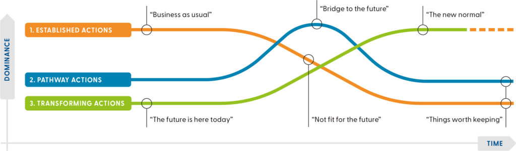
The tables present priority actions for the outcomes as:
- Established actions, which are those currently happening that we would like to continue. They include business as usual, recognised and existing practices. These are actions that are widespread and well-understood.
- Pathway actions, which are innovations that help shift from the current situation to an ideal future. For example, experiments, bridging or transition actions that take place during the transition from established to transforming actions.
- Transforming actions, which are the way things could work in the future. For example, the new normal, visionary ideas and new ways of doing things to create change. There may be pockets of these already happening.
A combination of all 3 types of actions is required to achieve the vision for the future (Figure 21).
Dividing actions this way is based on the Three Horizons framework and helps communities:
- think and plan for the longer-term by identifying emerging trends that might shape the future
- understand why current practices might not lead to a desired future
- recognise visionary actions that might be needed to get closer to a desired future.
Outcome 1: Agriculture is adapting to change, ensuring native vegetation, water, the economy and community critical attributes remain below tipping points
Table 32: Priority actions for outcome 1
| Action type | Priority actions |
|---|---|
| Established actions | • Improve weather literacy, awareness of weather forecasting services and earlier provision of information to prepare for upcoming dry seasons. • Demonstrations of technology, infrastructure and management packages that support the environment and farming businesses. • Demonstrations on-farm of new and current practices that actively promote and assist adapting to climate change, for example, ground cover all year round, minimal soil disturbance practices, managing water holding capacity in soils and dams. • Seek and make available technologies and services from outside the area that are relevant. |
| Pathway actions | • Explore alternative and/or additional incomes for farm business, such as honey, flowers, carbon or off-farm income. • Improve coordination of resources and services. • Implement land management practices to improve land function and address the impacts of historical land management practices. • Develop tools that quantify and measure the impact of land use and management practices on the critical attributes, such as the benefits of ecological systems to farms. • Investment in renewable energy infrastructure, such as solar farms, is appropriately located and designed to reduce and mitigate land impacts using the DELWP solar energy facilities – design and development guidelines. • Harness the diversity of land managers and approaches to build understanding and capability to adapt to climate change. |
| Transforming actions | • The community includes the impacts on the environment and society when making land use decisions. • A regional carbon credit initiative is trialled that enables urban people, including visitors, to offset their climate change impacts and contribute to funds for land managers to use for regenerating biodiversity, native vegetation and soil health. • Carbon farming is an integral part of land management to mitigate climate change. |
Outcome 2: Local improvement in the diversity, extent and connection of native vegetation and wildlife
Table 33: Priority actions for outcome 2
| Action type | Priority actions |
|---|---|
| Established actions | • Increase the extent and quality of native vegetation and create landscape corridors to help the movement of native species through remnant protection and revegetation projects. • Deliver programs that increase landholder and community awareness of the value of native vegetation and biodiversity to land management. • Investigate opportunities to increase the permanent protection of habitat on private lifestyle properties for native species. • Expand the Bogies and Beyond paddock tree project and use of the Tree Health app. • Highlight iconic native species for the area including food sources and shelter, such as sugar and squirrel gliders, goannas, button quail, golden sun moth, crimson spider orchid and creeping grevillea. • Continue to build awareness of the increasing value of biodiversity on farms and lifestyle blocks by linking it to increased amenity and land prices. • Strengthen public land managers efforts to protect, improve and maintain biodiversity. |
| Pathway actions | • Support the community to understand and embrace the provenance shift occurring due to climate change. • Quantify and build awareness of the value of improving and maintaining native vegetation, such as carbon, economic, lifestyle and health benefits, and integrate into existing and new decision making tools. • Reignite land stewardship, incorporating Traditional Owner values where permitted. • Increase the revegetation of high value linkages across landscapes that provide fauna habitat. • Biodiversity offsets are planted and of the same ecological vegetation class. • Support the development of mechanisms that credit private and public landholders and managers for ecosystem services, such as, biodiversity and carbon, that they provide to the broader community. • Support activities to increase the uptake of permanent protection of biodiversity on private land. |
| Transforming actions | • Public and private land managers set targets, actions and monitoring practices to maintain and improve native vegetation diversity, quality and extent. • Landholders are funded for the value they create, such as carbon, recreation and health, from biodiversity improvements and management. • Private landholders are supported to make decisions about biodiversity in a landscape context and for a range of climate scenarios. • Priority environmental assets, such as mature trees, are recognised in planning overlays and protected as linking habitats. • Build the Biodiversity Strategy for the Goulburn Broken Catchment into local planning schemes and use it to guide the strategic protection, linking and regeneration activities in the context of the broader landscape and climate change. |
Outcome 3: The community is cohesive, connected and collaborative
Table 34: Priority actions for outcome 3
| Action type | Priority actions |
|---|---|
| Established actions | • Improve awareness of available community groups, links and services, particularly for new landholders and farmers, such as information packs for new landholders. • Improve awareness of land management that has an impact at a landscape scale, such as weed control and installation of dams particularly for lifestyle properties. • Harness the diversity of land managers and approaches to build understanding and capability to adapt to climate change. • Match the Productive Plains to areas with the likely future climate, for example climate analogues, and identify suitable technologies, services and land use. • Build capacity of agency partners and Traditional Owners to engage in partnerships with shared priorities and outcomes. • Build community respect and support for Traditional Owners’ knowledge, culture and values. |
| Pathway actions | • Support the development of virtual centres to find information, who to contact and opportunities to learn. • Identify mentors for new farmers and create one-on-one or discussion group links. • Create opportunities for joint discussion, information sharing and program design between landholders and groups such as the CMA, Landcare and government. • Build community awareness, acceptance and understanding of the impact of the Central North Renewable Energy Zone. • Build the partnership, awareness and skills of the community around potential climate scenarios, technologies, services and land use from the matched climate area. • Greater inclusion and interest in Traditional Owners’ ecological knowledge and culture. • Work with CFA to discuss and implement fuel management activities with a focus on cultural practices, biodiversity and protection of lives and property. |
| Transforming actions | • Trusted metrics and tools support investment from the private sector in native vegetation management and improvement. • Landholders are funded for the value they create from biodiversity improvements and management. • Planning regulations support maintaining the critical attributes below tipping points and take into account the changing climate. • Community views drive decisions, planning regulations and priorities. • Communities integrate opportunities for renewable energy and carbon sequestration in decision making. • Traditional Owners lead NRM decision-making and implementation on public land. |
Outcome 4: Water use is adapting to change, ensuring native vegetation, the economy and community critical attributes remain below tipping points
Table 35: Priority actions for outcome 4
| Action type | Priority actions |
|---|---|
| Established actions | • Provide adaptation options to address water use. • Development of sustainable farm water plans, and support for watering systems on farm, adaptation options and increased habitat associated with on-farm water assets. |
| Pathway actions | • Develop and implement seasonal water plans considering likely climate change scenarios, particularly the exacerbated decline in runoff because of changes in rainfall and population. • Build in future climate change and population scenarios in water and local government planning. |
| Transforming actions | • The true and total costs and benefits derived from water are factored in water management. • Technologies and practices are adopted to improve water use efficiency and manage changes in water availability. • Planning and land use change requirements include available water and water use limits taking into account the impacts from climate change. |
References and further information
Barr N (2018) Socio-economic indicators of change – Goulburn Broken and North East CMA Regions [PDF 21.31MB], Natural Decisions Pty Ltd.
Benalla Rural City (2020) Council Plan 2017-2021 (2020 Review) [PDF 26MB], Benalla Rural City, Benalla.
Greater Shepparton City Council (2016) Council Plan 2017-2021, Greater S
Goulburn Broken CMA (Catchment Management Authority) (n.d.) Productive Plains SES Local Plan [PDF 730.06KB], Goulburn Broken CMA, Shepparton.
Strathbogie Shire Council (2016) Council Plan 2017-2021, Strathbogie Shire Council, Euroa.
Moira Shire Council (2016) Council Plan 2017-2021, Moira Shire Council, Cobram.
Show your support
Pledge your support for the Goulburn Broken Regional Catchment Strategy and its implementation.