As described throughout this strategy, urgent and large-scale change is required to improve the health of our natural resources and mitigate climate change. In addition to current activities and investment, we need to find alternative ways of doing things and new investment sources to respond to catchment drivers such as climate change, changing demographics and more diverse land use, and to reverse the declining health of the catchment’s land, water and biodiversity.
Resilient landscapes and thriving communities rely on our collective capacity to cope with change and flourish in spite of shocks or setbacks.
The development and renewal of this strategy and the Hume Regional Climate Adaptation Strategy has generated many new ideas on ways to improve catchment health, prepare for and minimise the impact of climate change and work better together.
To help get these ideas off the ground, the Goulburn Broken CMA in partnership with the Victorian Government’s Our Catchments, Our Communities and Climate Ready Hume programs funded six innovative projects in 2022. A further two projects were funded in 2023 through the Victorian Government’s Our Catchments, Our Communities Program and the Goulburn Broken CMA. An overview of each project is provided below.
1. Fingers on the pulse: Tracking the impact of climate change on the health of ecosystems in the Strathbogie Ranges
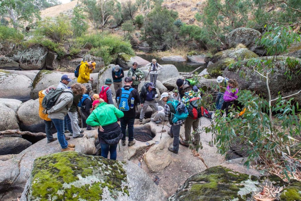
Strathbogie Ranges Conservation ‘Fingers on the pulse’ project aims to develop an online dashboard that collects and shares evidence on the direction and speed of environmental change in real-time.
Depicting key elements of climate change effecting the Strathbogie Ranges graphically via the dashboard should improve the ability of landholders, community members, businesses and organisations to track the likelihood of problems and flag the potential of natural disasters, as trigger points and thresholds are reached. This dashboard could also be used as a decision-making tool for setting environmental priorities.
The project is working with community members, university students and environmental experts to deliver the project, which will include identifying tipping points for action appropriate for the Strathbogie Ranges. For example, hotter than 45 degrees at ground level kills trees on rocky peaks.
As part of the project, climatic data (e.g. rainfall, groundwater levels, soil moisture and stream flow) will be linked to regular surveys of environmental assets, flora and fauna, to give a better indication of the health of local ecosystems. Baseline data collected as part of previous projects, as well as new data collected via volunteer community scientists and contractors will be used to measure ecosystem health.
For further information visit the group’s website.
This project has been made possible thanks to funding from the Victorian Government’s Our Catchments, Our Communities and Climate Ready Hume programs, and the Goulburn Broken CMA.
2. Understanding catchment condition with a refined eDNA tool for efficient and rapid fish population assessments
Fish are important indicators of catchment health, but traditional fish survey methods are challenging and expensive. eDNA analysis is a cheaper and potentially more powerful method of rapidly detecting fish in water without having to catch them.
This project, coordinated by the Threatened Species Conservancy, focused on refining an eDNA tool to detect fish species and evaluate the abundance and or biomass of fish in rivers, so that changes in fish populations can be more effectively assessed over time.
To validate the tool, water samples were collected across at least three rivers (and 15 sites) that had varying densities of three important fish species: Brown Trout, Rainbow Trout and the native Two-Spined Blackfish. The amount of fish eDNA in the water samples was quantified and compared to the number and biomass of fish determined during repeated electrofishing surveys undertaken over multiple spatial scales (transect distances of between 50-250m).
The project was delivered by the Threatened Species Conservancy in partnership with the University of Melbourne, Arthur Rylah Institute for Research, Wild Research and the Taungurung Land and Waters Council. Once developed, it is hoped that the eDNA tool will enable mangers and community groups to regularly evaluate the fish stocks in rivers throughout the Goulburn Broken catchment and elsewhere in Victoria, and ultimately this could be as simple as collecting a cup of water.
Results
The project had two major findings:
- A positive relationship between eDNA concentrations and the abundance and biomass of Two-Spined Blackfish and, to a lesser extent, Brown Trout;
- The strength of the relationship varied with the distance over which the fish populations were assessed. eDNA concentrations were most strongly associated with the abundance and biomass of Two-Spined Blackfish at a 250m transect length, while eDNA concentrations were most strongly associated with Brown Trout abundance and biomass within a 150m transect length. No relationship was identified for Rainbow Trout.
The eDNA-population relationships for Brown and Rainbow trout were difficult to evaluate due to the low numbers of each species captured at sites. These results indicate other factors are likely to influence eDNA concentrations and they must be identified before the eDNA tool can be used to reliably predict the relative abundance and biomass of the three fish species.
With this additional work, eDNA sampling has the potential to become a powerful approach to help estimate the abundance and biomass of fish populations. Until the sources of variation in eDNA concentrations are understood, traditional methods (like electrofishing depletion sampling) will be required to evaluate and track changes in fish populations.
This project has been made possible thanks to funding from the Victorian Government’s Our Catchments, Our Communities and Climate Ready Hume programs, and the Goulburn Broken CMA.
3. Building relationships to heal Country at Molesworth Billabongs
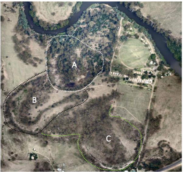
This project aimed to improve the recreational and ecological values at Molesworth Billabongs through track maintenance, vegetation management and other NRM activities.
Delivered by Taungurung Land and Waters Council (TLaWC) and its environmental services subsidiary, Biik Environmental, the project aimed to build capacity and establish relationships needed for future management activities, including environmental watering at the site.
Located at the Molesworth Conservation Reserve, the billabongs were identified in the mid-Goulburn habitat assessment by TLaWC and the GB CMA in 2020 as a key opportunity for future environmental watering to restore disconnected floodplain ecosystems.
The assessment identified significant cultural values and a potential for a significant improvement in ecological values should environmental water be delivered. A key identified barrier is a need to engage the wider community and in particular, the Committee of Management of the neighbouring caravan park, who are understood to have concerns including flooding risk and or mosquito breeding. The site (managed by Parks Victoria) is affected by invasive weeds (blackberry, willow) and the recreational infrastructure (walking track, bird hide) has fallen into disrepair.
The project will establish a community and stakeholder engagement process to involve the caravan park and other stakeholders in planning and prioritisation of works to address immediate management issues, while also engaging them in discussions regarding the delivery of environmental water to the billabongs.
Results
Flooding in late 2022 and early 2023 caused extensive impacts (e.g. damage to park infrastructure, sedimentation, debris, fallen trees and erosion of walking tracks) and the scope of works was reviewed to accommodate repairs.
The Biik Environmental field crew were able to re-establish and maintain the walking track to improve access, as well as clearing fallen trees, slashing, and weed control. They also made the bird hide operational again, repaired and maintained information boards, signage and benches, and established access along Waring (Goulburn River) for cultural use, walking, fishing and other recreational pursuits.
The project has fostered relationships between TLaWC, GB CMA, Parks Victoria and the Committee of Management and caretakers of the caravan park that will hopefully lead to a long-term commitment and ongoing weed control and slashing. An improved understanding of high-water flows through the billabongs during wet conditions will also improve any future water delivery activities (e.g. safe access, location for a temporary pump).
This project has been made possible thanks to funding from the Victorian Government’s Our Catchments, Our Communities and Climate Ready Hume programs, and the Goulburn Broken CMA.
4. Enhancing captive breeding for the re-introduction of Growling Grass Frogs to the Goulburn Broken Catchment
Amphibians are key indicators of wetland health. While Growling Grass Frogs were once common throughout the Goulburn Broken Catchment, few individuals and populations remain, and the species is now regarded as endangered in Victoria.
The Winton Wetlands Committee of Management, in partnership with regional stakeholders, are aiming to re-introduce the Growling Grass Frog to Winton as a key step to help restore the health of the wetlands across the 8,750ha site. The frogs are likely to play an important functional role in the ecosystem, given that they were historically an abundant predator and prey species.
Utilising recently built specialised quarantine and breeding facilities at the wetlands, this project provided funding to identify the locations of wild populations of Growling Grass Frogs, assess their genetic suitability for breeding, and establish a captive breeding program that can produce frogs for release to the wetlands and other parts of the catchment.
Surveys undertaken by the project will guide decision making about the capacity of existing wild population’s ability to support some frogs being removed for the captive breeding program and where extant populations are found with a low level of genetic diversity, recommendations for translocations to increase the diversity at those sites can be considered. Importantly, the project aimed to collect a genetically diverse group of individual frogs for the captive breeding program at Winton Wetlands to reduce the risk of in-breeding depression and maximise opportunities for establishing resilient wild populations.
Results
55 citizen scientists were recruited and trained to help find populations of Growling Grass Frogs using the Australian Museum’s Frog ID app through the project’s community engagement initiative Taskforce Growler and an online training course. Amphibian biologists from the University of Melbourne, Wild Research and the Threatened Species Conservancy also located populations of the frogs.
Once located, the genetic pedigree of the frogs was determined (by the University of Melbourne and Cesar Consultants) to ensure that a genetically diverse group of individual frogs was collected for the captive breeding program. Once selected, captured frogs were transferred to a specialised quarantine facility that was recently constructed at the Winton Wetlands. After a ~30-day quarantine period, to make sure individuals are not carrying disease, frogs were bred in a new breeding facility at Winton Wetlands for future release.
Other outcomes of the project included ‘Grub for Growlers’ program to engage schools and community members to assist growing food for the captive frogs and offspring, and the establishment of the Growling Grass Frog Practitioners Network of 50 scientists, managers and community experts to help advise and share information.
While the initial project is now completed, plans are underway to source funding to continue the work. The next phase of the project will aim to gather additional genetic data from the initial group of founders and the potential source populations in more detail, to refine captive breeding plans, explore the need for future wild collections and help track frogs following releases into the wild. Plans are also in place to assess other populations (Mildura, Dookie and Swan Hill) which may also be suitable for translocation in as part of future projects.
To learn more about the project, including an online video, click here.
This project has been made possible thanks to funding from the Victorian Government’s Our Catchments, Our Communities and Climate Ready Hume programs, and the Goulburn Broken CMA.
5. Developing a network of water stewards delivering improved water outcomes in the Goulburn Broken Catchment
Water stewardship creates water outcomes that are socially and culturally equitable, environmentally sustainable, and economically beneficial. It’s about using water sustainably, responsibly and ethically – taking positive action to benefit your catchment and ecosystem.
Water Stewardship Asia Pacific is introducing water stewardship to the Strathbogie, Benalla and Murrindindi local government areas by engaging local council, businesses and other stakeholders in addressing water catchment issues. Facilitated ‘Water Roadmap’ workshops will take several staff per organisation through assessment of 23 water-related indicators. Results presented through a ‘traffic light’ system, on a performance basis against pooled data, will highlight areas of strong performance and for improvement (see sample report below).
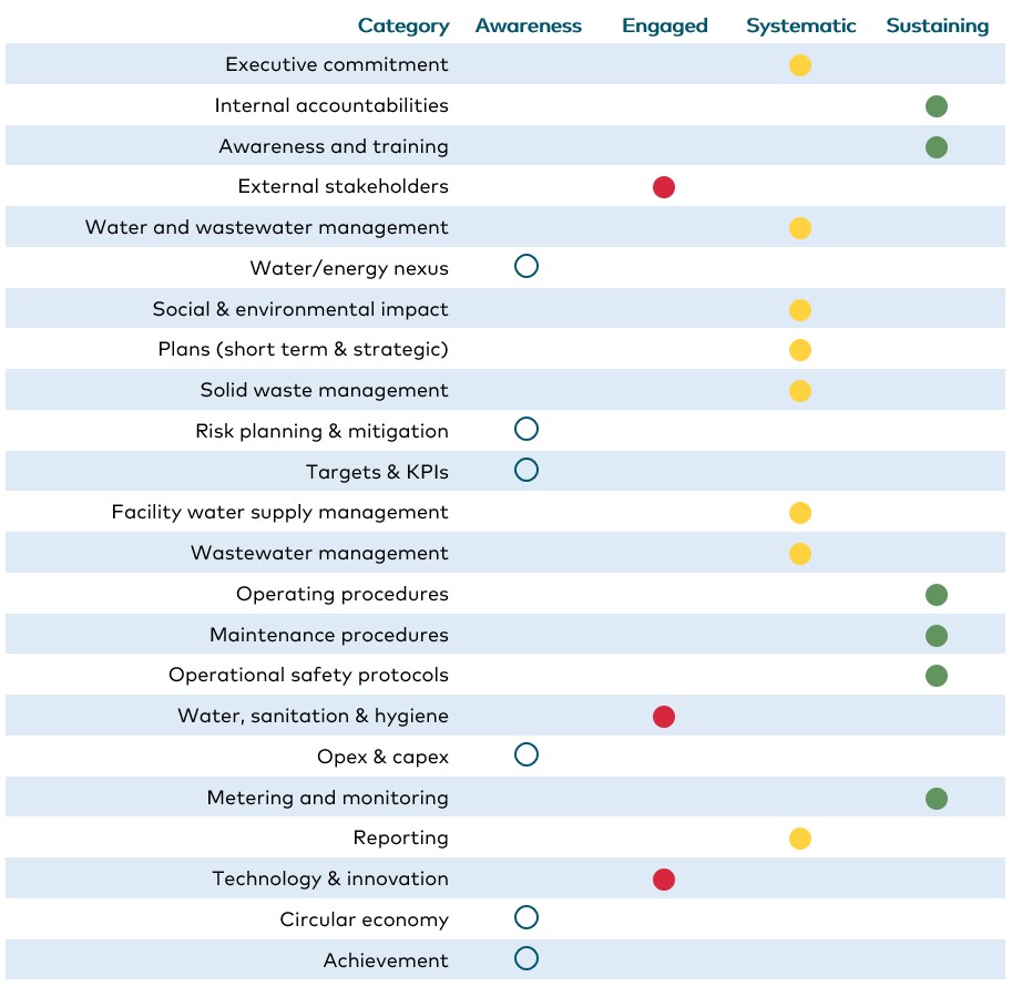
A joint work for participants will identify:
- Areas for improvement within the organisation (e.g. water use, efficiency, water security, resilience and community networks).
- Outcomes and opportunities to improve water catchment outcomes through collaboration with other stakeholders.
A catchment analysis addressing social, environmental and economic context will be developed, providing a framework for assessing water governance, management, risks and challenges, and will be available to help engage other catchment stakeholders in water stewardship.
The Water Roadmap, catchment analysis and new SEEWater Verification Program are based on the international ISEAL Water Stewardship Standard. These tools have been designed to build uptake by Australian business and organisations to address water challenges. The seed funding will be a catalyst for 5-6 industry leaders – including local government – to demonstrate good water governance and to offer a gateway to SEEWater verification.
Results
Five water roadmaps workshops have been delivered for Strathbogie Shire Council, Tahbilk Group, Benalla Rural City Council, Murrindindi Shire Council and On Point Brewery. A catchment analysis is also being prepared for the three local government areas. Uptake by local businesses and organisations was impacted by the significant flooding during 2022. The combined workshop with all participating organisations will be held in February 2024.
This project has been made possible thanks to funding from the Victorian Government’s Our Catchments, Our Communities and Climate Ready Hume programs, and the Goulburn Broken CMA.
6. Does participation in environmental markets build climate resilience? Goulburn Broken Catchment opportunities, risks and management
Broadening off-farm investment into natural resource management (NRM) should accelerate adoption of sustainable land management practices, improving the health of the region’s land, water and biodiversity and boost adaptation. However, environmental markets (i.e. off farm payments for producing environmental services) are a rapidly evolving and have many traps for new players. They are not a panacea, and if if purely carbon risk versus environmental stewardship values guide decisions, can be harmful to the long-term viability of farms, reduce landscape health and resilience.
BehaviourWorks Australia conducted a research project in the Goulburn Broken Catchment to answer the following three questions:
- Does participation in environmental markets build climate resilience?
- What are the relevant risks and opportunities for land managers in the catchment?
- What management strategies and support could help to increase the chances of positive outcomes for the catchment’s land managers?
The consortium conducted a rapid review of literature to assess what is known globally about Q1. They then ground this regionally via practice interviews with 8-12 NRM facilitators, adaptation professionals and subject matter experts. Working with the Goulburn-Murray Climate Alliance, a public forum was hosted to co-develop the key findings, and inform the final report, a two-page explainer and short video for local users.
Results
Risks and opportunities at the farm level identified in both interviews, global literature and the forum, reflect, and interact with dynamics at other scales. In particular, the perception that participating in environmental markets may be more risk than opportunity at present reflects a pragmatic view that farm businesses only have so much time and attention to spend on new opportunities, and that these have to be relatively well understood and certain before many land managers will act on them.
The fast moving economic and legislative environment, lack of trust in key mechanisms and intermediary actors and the underlying scientific uncertainty of what actually works, for how long, appear to leave many of our participants very cautious and uncertain about where to start. There was a keen sense of the interdependence of farm and community level interactions – that resilient farms are part of resilient communities and industries – and any transition to a different status quo would need to be just and equitable – at both intra- and inter-generational levels.
Against this, the promise of diversified income, more viable farms and regional communities and economies in the face of a changing climate, and bringing in wider ranges of actors including councils and indigenous corporations was also seen as promising. An overall sense of if not now, sometime soon, and with appropriate support and caution, seems to underline the sentiments expressed in the forum. This includes a commitment to expanding beyond carbon and biodiversity credits, to direct payments for environmental services, certification, and other forms of generating value from verifying and improving environmental services from land.
To learn more read the full report or 2-page summary, or watch the video below:
This project has been made possible thanks to funding from the Victorian Government’s Our Catchments, Our Communities and Climate Ready Hume programs, and the Goulburn Broken CMA.
7. Seed production area at Avenel
To future proof our natural environment to climate change and other shocks and disturbances, we need to collect, produce and store indigenous seed so it is available when we need it. Currently not enough seed is harvested to meet revegetation goals for the Goulburn Broken Catchment, furthermore collection is difficult due to fragmented sites and in some instances wild populations alone can not meet the demand for seed. A native seedbank is a vital safeguard to restore degraded landscapes, build resilience against natural disasters, and mitigate climate change.
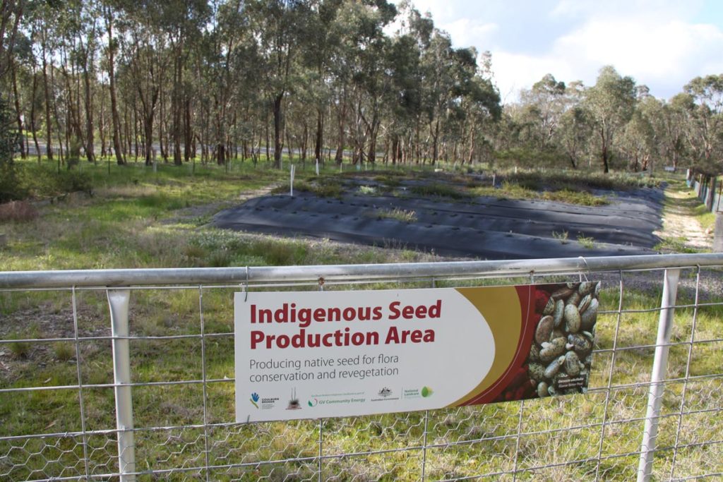
The Goulburn Broken Indigenous Seedbank and the Euroa Arboretum are establishing a 3-hectare seed production area at Avenel, as part of a broader goal to establish 100 Ha of seed production areas providing 1,000 kg of seed from 75 species within 5 years. While this initial site is small, it’s a significant step in this critical project.
The area will be planted with two commonly used species in revegetation projects across the catchment – 1,000 Mallee Wattles (Acacia montana) and 500 Bent leaf Wattles (Acacia flexifolia). This will provide bulk quantities of seed and ensure supply for the next 10 years of these species. Genetics utilised in the seed production area will be adapted to hotter, drier conditions and be from the catchment.
To find out more visit the Euroa Arboretum’s website or download a copy of the Growing Seed Strategy.
This project has been made possible thanks to funding from the Victorian Government’s Our Catchments, Our Communities Program and the Goulburn Broken CMA.
8. Community participation in ecological monitoring and natural capital accounting on farms in the Goulburn Broken Catchment
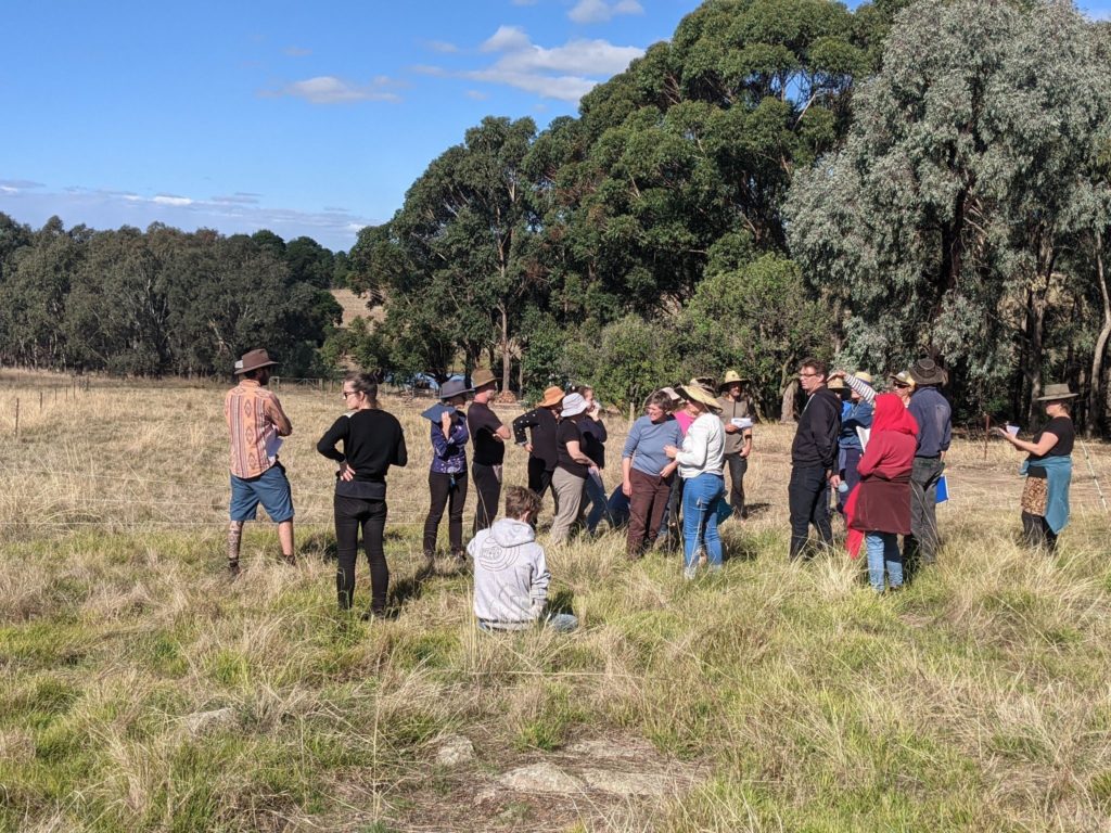
Pukawidgee Land Management is a non-profit farm in Warrenbayne that seeks to improve ecological function through farming and to create opportunities to share research and education about this. Pukawidgee has been funded by the Goulburn Broken CMA through the Victorian Government’s Our Catchments, Our Communities Program to explore how farmers and landholders can get more involved with on-farm ecological monitoring.
The project will involve an online information session in February 2024 and hands-on, one-day workshop on the first weekend of March 2024. This will be followed by an expression of interest process to form a smaller group of farmers from Goulburn Broken catchment to participate in farm visits, expert talks and hands-on data collection informed by their needs and specific goals.
The project will work closely with landcare networks and other groups supporting farmers in the region. It will focus on opportunities for DIY data collection and also emphasise the importance of tailoring activity to farm goals, personal capacity and resources. The project will include information around emerging opportunities in farm-scale natural capital accounting and new technology. It will focus on the importance of simple standardised methodologies and empower farmers to reduce reliance on costly systems and consultants.
To register to receive project updates please click here.
This project has been made possible thanks to funding from the Victorian Government’s Our Catchments, Our Communities Program and the Goulburn Broken CMA.
Show your support
Pledge your support for the Goulburn Broken Regional Catchment Strategy and its implementation.


